torsdag den 28. august 2008

Enspiria Solutions Aligns with Microsoft and ESRI to Provide Executive Dashboard Solution


ArcGIS Server i en integreret løsning på lige fod med Microsoft Office PerformancePoint Server 2007, Microsoft Office SharePoint Server 2007 og Microsoft Virtual Earth. Hvis man kunne var det tid til at købe ESRI aktier ...
/Sik


ArcGIS Server in an integrated solution together with Microsoft Office PerformancePoint Server 2007, Microsoft Office SharePoint Server 2007 and Microsoft Virtual Earth. If you could now would be a good time to spend money on ESRI stocks.
/Sik


Quote

Enspiria Solutions is working with Microsoft and ESRI to create a spatially enabled Utilities Executive Dashboard to aid a utility’s response to ever-increasing demands for more efficient, accurate and accessible data and services.

The dashboard is based on Enspiria’s Enterprise Oriented Architecture (EOA) development framework, a set of components that use the enterprise-class capabilities of Microsoft Office PerformancePoint Server 2007, Microsoft Office SharePoint Server 2007, Microsoft Virtual Earth and ESRI’s ArcGIS Server. The solution allows utilities to extract data from disparate sources and render it not only as charts and graphs, but also geographically.

[...]


Read more: http://tdworld.com/info_systems/vendor_updates/enspiria-microsoft-esri-0808/

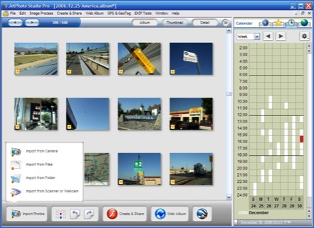
JetPhoto - Photo management app with tons of great features


Når du tager et billede gemmes en masse andre oplysninger i billedfilen end lige de xx mega pixels du indefangede. Har du et nyere kamera har du også en goekodning i blandt disse informationer. Hvis ikke findes der en masse programmer som kan hjælpe dig med manuelt at geokode dine billeder (hvis du gider). Uanset hvorledes dine billeder er geo tagget så findes der atter igen en masse tjenester til at vise dem på kort sammen med andre relevante og knap så relevante data. JetPhoto ligner et godt program som kan lidt af hvert og som blandt integrerer op imod Google Map / Earth.
/Sik


When you snap a photo informations other than the expected xx mega pixels are written to the image file. If you have a camera with built in GPS you have goecode informations as well. And if not there are plenty of programmes out there that'll help you manually to add geocoding information (if you care). No matter how your photos may have been geo tagged there are several sources to services that'll show the positions on a map. JetPhoto is a good all round program to manipulate photos, administer photos and it inegrates well with Google Map / Earth.
/Sik

Quote


Beside the standard image management tools such as making photo album, editing (automatic enhancing, black and white color effect, sepia color effect), resizing images in batches, archiving and backing up photos, importing (from camera, webcam, scanner, and other storage location); JetPhoto Studio enables user to organize photos by notes, keyword tags, camera status tags, time and geographical location. It also let user manage their photos by dates - which to many people is easier.

JetPhoto Studio has geo-tagging capabilities with smooth integration with Google Earth and Google Map. I don’t go around much so I don’t use this feature, but for those of you who are phototraveller, this one is a treat.

Another features most users will appreciate are the ability to create photo gallery - JetPhoto can easily make beatiful flash slideshows as well as lightbox web galleries, screensavers and desktop wallpaper, photo slideshow for presentation, and small images by resizing and cropping photo to fit most handphones and PDAs. Printing photo is also a snap either using your own printer or JetPhoto online printing service.


[...]

Computer viruses make it to orbit


Endnu er der ingen tilfælde af direkte virus angreb på GIS data og de applikationer som driver det. Men det er vel kun et spørgsmål om tid inden at man ser en grafitti på det ellers så pæne kort ...
/Sik


It is yet to be seen. A virus attack directed at GIS data and maps. But it is however just a matter of time before we see the first 'I was here' graffiti on a nicely mad map out there.
/Sik


Quote

A computer virus is alive and well on the International Space Station (ISS).
Nasa has confirmed that laptops carried to the ISS in July were infected with a virus known as Gammima.AG.

The worm was first detected on Earth in August 2007 and lurks on infected machines waiting to steal login names for popular online games.
Nasa said it was not the first time computer viruses had travelled into space and it was investigating how the machines were infected.


[...]


Read more: http://news.bbc.co.uk/2/hi/technology/7583805.stm

IE 8 Beta 2 ready for download


Quote

Mozilla did its best to throw a spoiler into Microsoft’s Internet Explorer (IE) 8 Beta 2 launch on Wednesday. But the new Ubiquity add-in for Firefox doesn’t sound all that different from what Microsoft is doing with the version of its browser due to ship in November.

That’s my take, but you can form your own opinion. Starting today, August 27, at 3 p.m. EST, Internet Explorer (IE) 8 Beta 2 became available for download by anyone who wants to give it a whirl.

[...]


onsdag den 27. august 2008

HAWX to Feature IKONOS Satellite Imagery on PS3, Xbox 360


Så kan den indbyggede flight simulator i Google Earth gpdt gå hjem og lægge sig ...
/Sik


The built in flight simulator in Google Earth has found its match ...
/Sik


Quote


Ubisoft has enlisted the help of GeoEye, a provider of satellite, aerial and geospatial information, to build the terrain maps for Tom Clancy's HAWX air combat game on Playstation 3 and Xbox 360.

Ubisoft's HAWX team is using information shot from the IKONOS satellite to put directly into HAWX's 16 international locations including Rio de Janeiro, Cape Canaveral and the Middle East.

The team also worked with the United States Geological Service (USGS) and Center for Earth Resources Observations and Science (EROS) to understand the concept of topographical 'underpinning' to create a realistic representation of the earth.

[...]


Read more: http://www.thehdroom.com/news/HAWX_to_Feature_IKONOS_Satellite_Imagery_on_PS3_Xbox_360/3359

Nations Respond To Google Earth Threat


Intet er så godt at det ikke er dårligt for noget/nogen.
/Sik


Nothing is good enough not to be bad too.
/Sik


Quote

From banning Google Earth to simply ignoring the mapping service, countries are working to deal with potential security violations arising from the images Google makes available online.
[...]

Asking Google to have imagery removed or blurred has gotten easier since terrorists were confirmed to be using the software to plan attacks in 2006 and 2007, the report says. Following news reports in January 2007 that terrorists attacking British bases in Basra, Iraq were using Google Earth as a planning tool, Google "seemingly became more open to dealing directly with foreign governments to assuage their security concerns," the report says.

[...]


Read more: http://www.informationweek.com/news/internet/google/showArticle.jhtml?articleID=210200882

Tories commit $100 million over five years to map Arctic resource riches


Den globale opvarmning åbner op for nye områder med fossile brændstoffer som igen vil øge ... den globale opvarmning.
/Sik


Global warming has opened new areas with vast resources of fossilized fuel which in turn will increase ... global warming.
/Sik


Quote
OTTAWA — Prime Minister Stephen Harper has announced a major project to map geological resources in Canada's Arctic.

Declaring "use it or lose it" as the "first principle of Arctic sovereignty," Harper says the program will use geological sciences and technology to determine the North's development potential.

A total of $100 million has been set aside over the next five years to complete an on-shore geo-mapping exercise of the North.

[...]

"What we've found so far is merely the tip of the proverbial iceberg," Harper said.

"Managed properly, Canada's share of this incredible endowment will fuel the prosperity of our country for generations. And geo-mapping will pave the way for the resource development of the future."

[...]


3 Top Data Formats for Map Mashups: KML, GeoRSS and GeoJSON


KML, GeoRSS eller GeoJSON?
/Sik


KML, GeoRSS or GeoJSON?
/Sik


Quote

Map mashups continue to mature in terms of sophistication and functionality, providing end users with an ever-expanding set of tools and applications. As a result, the intersection between traditional geospatial data and these new map mashups requires well defined ways to transfer, distribute, and consume geospatial data in a web-friendly way.

Some new geospatial data formats have emerged in response to this need, enabling a broad spectrum of users and developers to mashup information in a geographic context. Here is a rundown of the three primary formats for geo- mashup developers today:

[...]


Read more: http://blog.programmableweb.com/2008/08/27/3-top-data-formats-for-map-mashups-kml-georss-and-geojson/

The Geospatial Web: A Call to Action


Hvad skal vi med fremtiden og hvad skal der til for at få den?
/Sik


Is the future useable and if not how do we make so?
/Sik


Quote

What We Still Need to Build for an Insanely Cool Open Geospatial Web
by Mike Liebhold, contributor to O'Reilly's upcoming Mapping Hacks
05/10/2005

Editor's note: In this article, Mike Liebhold writes about what we need to do to tap the as yet unharvested business opportunities in a geospatial web. This is just the type of topic we'll be exploring at the O'Reilly conference Where 2.0, coming to San Francisco in late June. Join us to learn how vendors, application developers, and consumer web companies are using GPS, RFID, WLAN, cellular networks, and networked sensors in new ways to solve old business problems.

Beyond a growing commercial interest in mobile GIS and location services, there's deep geek fascination with web mapping and location hacking. After several years of early experiments by a first generation of geohackers, locative media artists, and psychogeographers, a second, larger wave of hackers are demonstrating some amazing tricks with Google Maps, Flickr, and del.icio.us. Meanwhile, a growing international cadre of open source digital geographers and frontier semantic hackers have been building first-generation working versions of powerful new open source web mapping service tools based on open standards like WMS (web map services) and WFS (web feature services), all built on GML (geographic markup language) and XML. You can see for yourself: hundreds of new geospatial web-related links from perhaps thousands of geeks and users are aggregated daily at del.icio.us/inbox/starhill_blend.

[...]


Read more: http://www.oreillynet.com/pub/a/network/2005/05/10/geospatialweb.html

ESRI’s New ArcGIS API for Flex Improves the Look and Feel of Web Mapping Applications


ESRI viser for en gang skyld lidt lir for synsnerven.
/Sik


ESRI finally dares to show off.
/Sik


Quote

Beta Version of ArcGIS API for Flex Gives Developers Direct Access to ArcGIS Server 9.3

Redlands, California—ESRI announced the new ArcGIS API for Flex Beta at the ESRI International User Conference in San Diego, California, which was held August 4–8, 2008.

ArcGIS API for Flex is integrated with Adobe Flex Builder 3 and can be downloaded for free from ESRI. Flex is a client-side technology that is rendered by Flash Player 9 or Adobe AIR. This means that application developers now have the capability to combine geographic information system (GIS)-based Web services from ArcGIS Server with other Web content and display it in fast, visually rich, and expressive mapping applications that can be deployed over the Web or to the desktop.

[...]


Read more: http://www.directionsmag.com/press.releases/index.php?duty=Show&id=24534&trv=1