onsdag den 29. juli 2009

Video: Back to School - Flash as Web Format


Den første video en serie fra Adena ...
/Sik


The first in a row of educational videos from Adena ...
/Sik


Quote


(c) Adena Schutzberg, 2009


Read more: http://www.directionsmag.com/article.php?article_id=3231

Geospatially-Aware Acrobat 9


Det ser interessant ud ...
/Sik


This should interesting ...
/Sik


Quote

If you weren’t able to catch the Acrobat eSeminar “Break down GIS information silos using Acrobat 9” presented by Tomas Lopes of Farallon Geographics, you can now view it online. The video showcases on how to use the new geospatially-aware Acrobat 9 to communicate geospatial information and provide mapping capabilities to field workers and other users. [...]

Bookmaplet: Easy Online Street Mapping


Smart lille knap ...
/Sik


Nifty little application ...
/Sik


Quote

  1. Highlight one of the following addresses/places:
- The Little Mermaid
- Niels Bohrs Alle 185, Odense
-
Liberty Island, New York, NY, United States
  1. Click this button Map that address and you'll get a map showing the address or place
  2. Copy the button to your web page and it'll work there too ...

Read more: http://www.bookmaplet.com/

tirsdag den 28. juli 2009

FOX News Doesn’t Know Where Iraq Is


Det værste er at artiklen fortsætter med et vise et Bing map hvor man kan se med egne øjne at det er Irak og ikke Egypten, skulle man være i tvivl ...
/Sik


Americans ...
/Sik


Quote

by JOEY DEVILLA

In a comment to an earlier article of mine showing FOX News’ tendency to mislabel badly-behaving Republicans as Democrats, “RODAN” pointed me to this map of the middle east shown on FOX News in segment where Neil Cavuto interviewed John Bolton on Monday – note the country marked “Egypt”:

FOX News' map of the middle east, putting Egypt where Iraq is.

[...]


Read more: http://www.joeydevilla.com/2009/07/28/fox-news-doesnt-know-where-iraq-is/

Beauty and an easy route to death have long made the Golden Gate Bridge a magnet for suicides


Jeg kikkede en ekstra gang da jeg så skiltet og telefonen (se foto nedenfor), men der er tilsyneladende et stort behov ...
/Sik


I had to look twice when I first saw the sign and the phone (see photo below) but sadly it is very much needed ...
/Sik


Map2PDF : Printing web maps to PDF


Så mangler vi bare en signaturforklaring, målfast plot, printhoved, logo, osv ...
/Sik


And a legend?
/Sik


Quote

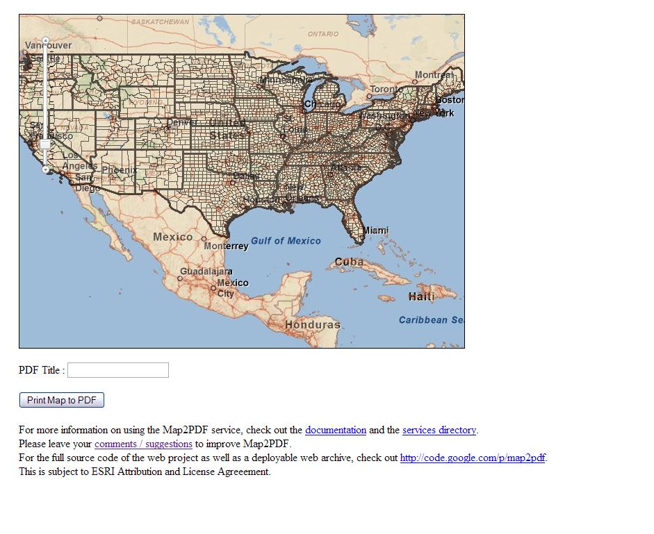
A lot of people have been wanting to print web maps authored with the ArcGIS JavaScript API. There have also been numerous requests for the ability to print web maps as a PDF. This is a simple RESTful service called Map2PDF, that exposes the ability to print web maps as PDF. Check out this sample, that uses the Map2PDF RESTful web service.

There is support for Tiled Map services, Dynamic Map Services as well as Graphic Features (limited support). The sample also includes a PrintMap.js script, that helps developers serialize the 'map state' in a format that the Map2PDF service expects.

The web service uses the Java Advanced Imaging API for mosaicing and overlay of images. Graphic Features are rendered on the server side using java.awt.Graphics2D. The iText PDF engine is to generate the PDF's.

For more help on how to effectively use Map2PDF check out the API
documentation and the services directory page.

If you want to deploy the application on your own Servlet container, you can download the web archive.

[Update]
Additional instructions included in README.txt to help deploying this application on a web server.


Authorrahulr
Date Submitted07-07-2009
Date Last Updated07-27-2009
LanguageJavaScript
Product/VersionArcGIS Server 9.3.1
Views860
Downloads194
License TypeESRI Attribution and License Agreement
(0 ratings)


Read more: http://resources.esri.com/arcgisserver/apis/javascript/arcgis/index.cfm?fa=codeGalleryDetails&scriptID=16432

Mapify a MediaWiki with New Extension


FYI
/Sik


FYI
/Sik


Quote

Adam DuVander

The project that runs Wikipedia has added improved mapping extensions that let you embed Yahoo or Google Maps within your Wiki pages. Special markup is translated to API calls, which keeps out JavaScript that would be required if creating maps directly.

Once the Maps extension is installed, anyone editing a MediaWiki page can include the familiar Wiki syntax with curly brackets. [...]


MediaWiki Maps on OpenLayers

Read more: http://blog.programmableweb.com/2009/07/28/mapify-a-mediawiki-with-new-extension/

Tech Girls are Chic!

Book


Teach girls to be part of the techie future

Tech Girls are Chic is a fun new book showing that it takes all types of people to work in IT. Inside, you'll find stories by 16 'tech girls' - awesome techie ladies working in a range of technology jobs across Australia (and even though they are all Australian, they serve as a great sampling of techie jobs all over the world). They are a bunch of fun and funky women who find working with technology challenging and interesting, and they are far from fitting the stereotypical 'geek' image portrayed by the media. They use their technical and/or non-technical skills (usually a combination of both) to have a successful career in IT.

Aimed at girls aged 12-16, Tech Girls are Chic also has wide appeal to educators and employers. As the number of females studying and working with technology is at an all time low, this book hopes to inspire girls to think a little deeper about technology - what they like about it, what they are good at, and what are the things that are important to them in their future career. Because in order for the future to be as golden as possible, both dudes and dudettes (together) need to push the tech field as far as it can go - and then some.

Author: Compiled and Edited by: Jenine Beekhuyzen & Rebecca Dorries
Publisher: Madly Creative
ISBN: 978-0-9803205-2-7
Pages: 72
Covertype: Paperback
Year: 2008
Edition: 1st
Genre: Tech for Girls


Buy: http://www.thinkgeek.com/books/nonfiction/baa1/

mandag den 27. juli 2009

BBC: The Truth About Crime


Fascinerende og tankevækkende ...
/Sik


Fascinating and yet thought provocing ...
/Sik


Quote


Why do we think crime is rising, when the official figures suggest it is coming down?

This three-part documentary series follows presenter Nick Ross on a journey to learn the truth behind the crime headlines.

The programme conducts a unique Crime Audit: Filming 24/7 for a fortnight with the emergency services in one city, Oxford, whose crime pattern is typical of Britain as a whole, the cameras reveal what crime in one city really looks like. Using official crime figures, the series creates crime maps to show patterns of crime - when and where it happens. But The Truth About Crime also carries out an online questionnaire of the population of Oxford and the largest ever survey of the city's school children, to uncover people's hidden experiences and feelings about crime.

In the first episode, Violent Crime, Nick reveals the extent to which alcohol fuels violent crime on the street and in the home, but how there is also a lot that can be done to combat it.

In each film of the series - episode two explores Theft and Burglary; and the final one, Anti Social Behaviour - Nick asks how likely we are to be a victim of crime. He follows the stories of individual victims filmed during the crime audit to see how they are treated by the police, prosecutors and the courts. Finally, he looks beyond the Criminal Justice System to see what can be done to stop crime happening in the first place.


Read more: http://www.bbc.co.uk/truthaboutcrime/crimemap/

BCS HyperPic.Mobile GIS Photo Inspection and Management Solution


Billeder taget på et givent sted er nok noget af det mest informationsrige man kan tilføje sine data. Hvordan så det ud der hvor man gravede for 5 år siden? Hvilken pumpetype blev anvendt under dækslerne? Hvor stod den gamle lysmast?
I mit indlæg ved Powel stormødet i år snakkede jeg om brugen af fotos sammen med de tekniske kort (http://www.slideshare.net/gisguru/kort-nyt-er-godt-nyt - Starter på slide 104).
Den helt store udfordring er at få vist billederne augmented så de smelter tilbage ind i virkeligheden ...
/Sik


Photos taken on a given spot may be one of the most information rich medias you can use and add to your conventionel data. What did it look like 5 feet down 5 years ago? What kind of pumps were used under those heavy well covers? And where did that old light pole stand 30 something years ago?
The biggest challenge here is to merge these augmented data back into reality ...
/Sik


Quote

GeoMobile, in partnership with Bradshaw Consulting Services, is the exclusive western United States reseller of BCS’ HyperPic.Mobile, an easy-to-use solution that streamlines data collection and photo management. Designed to tightly integrate with your existing GIS infrastructure, HyperPic can add multiple photos to both new and existing features and is compatible with most cameras.


The release of HyperPic.MOBILE provides an easy-to-use solution for emergency response departments, city and county governments, utility providers, military groups, oil and gas companies, and other organizations utilizing photos to supplement their GIS data. With HyperPic.MOBILE, which is an extension to ESRI's ArcPadr software, field workers can take multiple photos using any digital camera, and with the click of a button link the photos with related GIS data on any mobile device with a Windows Mobiler operating system. Back in the office, the images can also be linked with the corresponding data in the enterprise GIS with the click of a button.

"We work with customers in all types of industries, all around the world, and the one thing they all had in common was the need for a better way to collect and manage photos in the GIS," said Christopher Bradshaw, mobile technologies manager at Bradshaw Consulting Services. "With HyperPic.MOBILE, field workers can attach a virtually unlimited number of photos to field data, which gives managers even greater visibility into new and existing features. The software is easy to install, easy to learn, and easy to use, and it's already making our early adopters' GIS data more useful."

HyperPic.MOBILE features enable users to add or remove photos in ArcGISr Desktop as well as add or view photos in ArcPad. Users will also be able to utilize ArcGISr Mobile in the near future. The software also includes a built-in photo viewer for ArcGIS Desktop. For more information, please visit www.bcs-gis.com.


Read more: http://www.geomobileinnovations.com/products/bcs-hyperpicmobile-gis-photo-inspection-and-management-solution