mandag den 5. juli 2010

GOCE giving new insights into Earth’s gravity


Newton har ikke levet forgæves ...
/Sik 


Newton on a global scale ...
/Sik


Quote

The first global gravity model based on GOCE satellite data has been presented at ESA’s Living Planet Symposium. ESA launched GOCE in March 2009 to map Earth's gravity with unprecedented accuracy and resolution.
 
The model, based on only two months of data, from November and December 2009, shows the excellent capability of the satellite to map tiny variations in Earth’s gravity.

"GOCE is delivering where it promised: in the fine spatial scales," GOCE Mission Manager Rune Floberghagen said.
"We have already been able to identify significant improvements in the high-resolution 'geoid', and the gravity model will improve as more data become available."
The geoid is the shape of an imaginary global ocean dictated by gravity in the absence of tides and currents. It is a crucial reference for accurately measuring ocean circulation, sea-level change and ice dynamics – all affected by climate change.  [...]


Read more: http://www.esa.int/esaEO/SEMY0FOZVAG_index_0.html

lørdag den 3. juli 2010

ArcGIS for iOS - Extend GIS to the iPhone and iPad


Endnu er argument for at få en (firmabetalt) iPhone ...
/Sik


iMap on the ArcPhone ...
/Sik

ArcGIS for iPhone

Quote


ArcGIS for iOS allows you to navigate maps, collect and report data, and perform GIS analysis. It is a part of the ArcGIS system and is a great way to
  • Discover content by browsing map galleries from ArcGIS Online or leverage your existing enterprise GIS services.
  • Display maps and capture information.
  • Develop a custom application or brand your own iOS app specific to your business needs.
  • Extend your GIS to a wider audience.
ArcGIS for iOS application will be available for download in the Apple App Store in early July 2010.
ArcGIS API for iOS is estimated to be officially released third quarter of 2010.


Read more: http://www.esri.com/software/arcgis/ios/index.html

fredag den 2. juli 2010

Map of Human Sexuality


Noget for kort fetichister?
/Sik 


Even maps can be sexy too ...
/Sik

 Quote


Read more: http://s3.amazonaws.com/data.tumblr.com/tumblr_l4slxqiyqk1qadtr5o1_1280.gif?AWSAccessKeyId=0RYTHV9YYQ4W5Q3HQMG2&Expires=1278187153&Signature=Z6Ix1rMxCzik7rXLIHHFxxTZd5I%3D

onsdag den 30. juni 2010

An Artistic View On the World

Extra! Extra! Google News redesigned to be more customizable and shareable


Kun engelsk ...
/Sik


Why mention Google News on a GIS blog? Well, the introductory lines are true in many ways and if you change the word news with the word GIS you may get even more truth ...

There’s an old saying that all GIS is local. But all GIS is personal too—we connect with it in different ways depending on our interests, where we live, what we do and a lot of other factors.

/Sik

Quote
There’s an old saying that all news is local. But all news is personal too—we connect with it in different ways depending on our interests, where we live, what we do and a lot of other factors. Today we’re revamping the Google News homepage with several changes designed to make the news that you see more relevant to you. We’re also trying to better highlight interesting stories you didn’t know existed and to make it easier for you to share stories through social networks.

Before:


After:


The new heart of the homepage is something we call “News for you”: a stream of headlines automatically tailored to your interests. You can help us get it right by using the “Edit personalization” box to specify how much you’re interested in Business, Health, Entertainment, Sports or any subject you want to add (whether it’s the Supreme Court, the World Cup or synthetic biology). You can choose to view the stories by Section view or List view, and reveal more headlines by hovering over the headline with your mouse. We’ll remember your preferences each time you log in. If you don’t want customized Google News, hit “Reset personalization" to clear all personalization preferences. If you haven't previously customized and would prefer not to, simply save and close the “Edit personalization” box. You can always go back and change it later.

To give you more control over the news that you see, we’re now allowing you to choose which news sources you’d like to see more or less often. You can do so in News Settings. These sources will rank higher or lower for you (but not for anyone else) in Google News search results and story clusters. We’ve also added keyboard shortcuts for easier navigation, like in Gmail or Google Reader. When you’re in Google News, hit the question mark key to pop up a full list of shortcuts.

There are the subjects that interest you and then there’s the major news of the day. To make it easy for you to find the big stories like Hurricane Alex, we’re adding links to topics that many outlets are covering. You’ll find these topics in the Top Stories section on the left side of the homepage as well as in linked keywords above headlines. Clicking on a topic link takes you to a list of related coverage that you can add to your news stream. You can change your preferences any time in “Edit personalization.”


We’re also more prominently displaying the Spotlight section, which features stories of more lasting interest than breaking news and has been one of our most popular sections since we introduced it last fall. And then there’s local news; we’re now highlighting weather and headlines about your city or neighborhood in their own section, which you can edit with whichever location you want to follow.

Finally, you can now easily share story clusters with other people via Buzz, Reader, Facebook or Twitter. Just select the drop-down menu marked by an arrow on the top-right of each story cluster. In the drop-down, you can also choose to see more or less of the first news source.
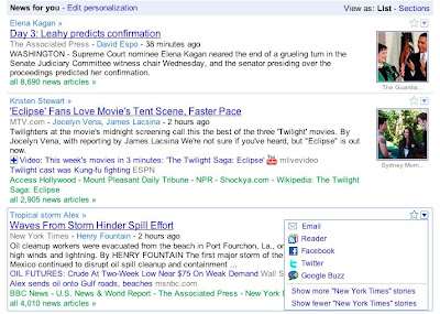

The redesigned Google News homepage is rolling out today in the English-language edition in the U.S., and we plan to expand it to all editions in the coming months. We’re making the ability to choose which sources you’ll see more or less often available in all English-language editions worldwide and plan to expand it soon.

Read more: http://googleblog.blogspot.com/2010/06/extra-extra-google-news-redesigned-to.html

Beat the Traffic 3D® Broadcast Traffic Reporting


Fremtidens trafik vil bestå af enheder som kæmper for at beregne den bedste rute fra A til B via bedste punkter C og D og ...
/Sik


Cool graphics, cool animations, and cool visulizations ... What would traffic be like if all had all information?
/Sik

Quote
Beat the Traffic's award-winning, high-definition traffic system provides an easy-to-use, 3D mapping environment designed to highlight traffic information for viewers.
The Beat the Traffic 3D mapping application produces clear, customizable, information-rich animations.
Inspired from flight simulation technology, the Beat the Traffic-3D live-to-air system produces clear, customizable, information-rich animations. There is no pre-rendering involved yet the fluidity of the animation is not compromised. Traffic flow and incidents are visualized using intuitive animations, incorporating familiar three-dimensional icons. An intuitive, easy to use web-based control panel allows you to customize and override the automated data. [...]


Read more: http://www.trianglesoftware.com/3d_mapping.aspx

Cool iPhone app gives lowdown on any neighborhood


Kun amerikansk ...
/Sik


iSpy ... Get to know your neighboors ;-)
/Sik

Quote

[...]

The iPhone app, called Business Analyst Online, or BAO, links back to a wealth of geocoded demographic data stored in ESRI's geographic information system databases. Best of all, you can tap it for free.

"We think it’s really cool, because unlike any other app it will allow you to really check out a location, find out what it’s like and what kind of people live there," says Lead product manager James Killick.

Killick says ESRI is providing more than just rehashed Census data. "It’s updated demographics created by ESRI’s team of demographers, statisticians and economists who have been involved with building these kind of data sets for over 35 years," he says.

BAO was created with the needs of the real estate industry in mind, Killick says, but a search function will allow anyone to find locations that meet specific demographic criteria. [...]


Zoom to Location The Neigborhood Compare


Read more: http://blogs.computerworld.com/16439/cool_iphone_app_gives_lowdown_on_your_neighborhood

World Cup Mashup combines twitter posts to show the public's predictions of World Cup scores


Kan man vinde noget?
/Sik


What can I win?
/Sik

Where Will the Next Volcano Erupt?


Det er en farlig verden vi lever i ...
/Sik


Booom ...
/Sik

Quote
The April 14 eruption of Iceland's Eyjafjallajökull volcano disrupted air traffic over much of Europe and stranded thousands of passengers across the world. The total cost is estimated to be $5 billion in lost GDP through May 24, 2010. But now that dust has cleared, we can see that the eruption was small by historical standards, and there is always the chance of a bigger one: At any given time there are roughly 20 active volcanoes around the world, and there are 16 volcanoes—called "Decade Volcanoes"—that are currently noted to have a history of large eruptions and a proximity to populated areas. Imagine the cost if one of those erupts.

A GOOD.is Transparency

Read more: http://www.good.is/post/transparency-where-will-the-next-volcano-erupt/

tirsdag den 29. juni 2010

GearScape is a Geographic Information System platform dedicated to geoprocessing


En kort definition af GP: Geoproccessering går grundlæggende ud på at automatisere GIS opgaverne. Næsten alle former for GIS arbejde indebærer en stor del af gentagelser af de samme trin igen og igen. Dette skriger efter en eller anden form for maskineri til at definere og replikere disse processer. Geoprocessering er lige netop dette og indbefatter også dette at kunne kombinere flere af disse i serier af operationer. Denne process defineres vha. modeller og scripts ...
/Sik


The fundamental purpose of geoprocessing is to allow you to automate your GIS tasks. Almost all uses of GIS involve the repetition of work, and this creates the need for methods to automate, document, and share multiple-step procedures known as workflows. Geoprocessing supports the automation of workflows by providing a rich set of tools and a mechanism to combine a series of tools in a sequence of operations using models and scripts. [See more]
/Sik