fredag den 2. oktober 2009

Charting the Final Frontier--Google Maps for Indoors


Google finder den korteste vej fra soveværelset og til køkkenet ...
/Sik


Big Brother is mapping you ... Give me directions to the kitchen please ...
/Sik


Quote

[...]

Available as a free service to users of the iPhone, BlackBerry, Palm or Android mobile handsets, Micello displays the Google maps to an address adorned with icons showing where indoor maps are available. Once the user arrives at an address, clicking on the Micello icon overlays the indoor map. Search for a particular venue inside, and Micello highlights a recommended route from your current location. Future versions will also provide directions from your car in the parking lot, as well as store-to-store directions once inside a mall.

Micello also plans to personalize maps by highlighting items that may be of interest to users based on their profile and history, as well as allow them to share their location with Facebook friends, Twitter followers or LinkedIn contacts. In addition, users will be encouraged to crowd-source information about destinations by posting reviews about points of interest.

When Micello becomes available later this fall for the iPhone, it will come with maps for 150 points of interest in the Bay Area, with the rest of California slated for mapping by the end of the year. The other major cities, plus versions for BlackBerry, Palm and Android, are promised by the end of 2010, at which time Micello estimates it will have 5,000 shopping malls, 10,000 college campuses and 400 convention centers in its growing database. Locations will also include airports, stadiums, theme parks, golf courses, fitness centers and other venues where people naturally congregate. [...]


Read more: http://www.smartertechnology.com/c/a/Technology-For-Change/Charting-the-Final-FrontierGoogle-Maps-for-Indoors/

GIS Is Key to 21st Century Skills


Der er GIS i alt - vor tids teknologi har synliggjort dette for de fleste - så uanset hvad man arbejder med kan man kun blive bedre med GIS kundskaber ...
/Sik


GIS is in everything - technology today has made it obvious for most - no matter what you work with you need GIS skills ...
/Sik


Quote

Educational researchers and policymakers increasingly call for “21st Century skills.” What exactly are these skills, and why are they important for education? One advocacy organization focused on this is the Partnership for 21st Century Skills, which since 2002 has brought together business, education, and policy leaders to define these skills and indicate how they can be applied to education. These skills include information and communication, thinking, problem-solving, interpersonal and self-direction, global awareness, economic and business literacy, entrepreneurial, and civic literacy. The Partnership’s belief is that “every child in America needs 21st Century knowledge and skills to succeed as effective citizens, workers, and leaders” and that a gap exists between this knowledge and skill set and what students are currently learning in school.

Recently, diverse groups gathered to produce “skills maps” that connect these skills with specific content areas. Thus far, English, Social Studies, Science, and Geography skills maps have been completed. The National Council for Geographic Education formed a team, including NCGE members from ESRI, universities, and schools, to create the Geography Map [PDF]. Geotechnologies such as Geographic Information Systems, GPS, and Remote Sensing are prominently featured throughout this document. The reason why is that they can serve as powerful tools for spatial inquiry, fostering critical thinking skills about a host of issues from local to global—from natural hazards to population to invasive species, and beyond. Because GIS is a system, using it requires the ability to gather, manage, and make decisions based on real data in real contexts.

In an interview for the article, “New maps infuse 21st Century Skills”, I stated that geotechnologies help students “engage in spatial analysis and inquiry that will prepare them for today’s rapidly changing world.” For example, eighth-graders identify historic and contemporary migrant groups in their area, examine why migration occurs, investigate the changes that occur when people migrate, and present their findings.

It is our hope that these 21st Century skills maps encourage administrators and educators to infuse these skills into the curriculum to best prepare students for the future.

- Joseph Kerski, ESRI Education Manager


Read more: http://blogs.esri.com/Info/blogs/gisedcom/archive/2009/10/02/gis-is-key-to-21st-century-skills.aspx

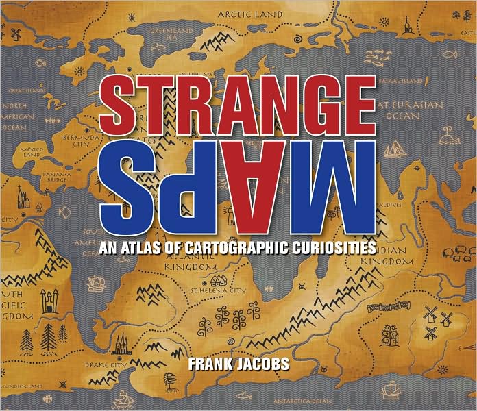
Strange Maps: An Atlas of Cartographic Curiosities

Book

Cover Image

An intriguing collection of more than one hundred out-of-the-ordinary maps, blending art, history, and pop culture for a unique atlas of humanity

Spanning many centuries, all continents, and the realms of outer space and the imagination, this collection of 138 unique graphics combines beautiful full-color illustrations with quirky statistics and smart social commentary. The result is a distinctive illustrated guide to the world. Categories of cartographic curiosities include: • Literary Creations, featuring a map of Thomas More's Utopia and the world of George Orwell's 1984

• Cartographic Misconceptions, such as a lavish seventeenthcentury map depicting California as an island
• Political Parody, containing the "Jesusland map" and other humorous takes on voter profiles
• Whatchamacallit, including a map of the area codes for regions where the rapper Ludacris sings about having "hoes"
• Obscure Proposals, capturing Thomas Jefferson's vision for dividing the Northwest Territory into ten states with names such as Polypotamia and Assenisipia
• Fantastic Maps, with a depiction of what the globe might look like if the sea and land were inverted

The Strange Maps blog has been named by GeekDad Blog on Wired.com "one of the more unusual and unique sites seen on the Web that doesn't sell anything or promote an agenda" and it's currently ranked #423 on Technorati's Top 500 Blogs.

Brimming with trivia, deadpan humor, and idiosyncratic lore, Strange Maps is a fascinating tour of all things weird and wonderful in the world of cartography.


Buy: http://search.barnesandnoble.com/Strange-Maps/Frank-Jacobs/e/9780142005255/?itm=1

ArcGIS JavaScript API 1.5 released


FYI
/Sik


FYI
/Sik


Quote

What's new in Version 1.5

The following are new features in version 1.5 of the ArcGIS JavaScript API.

Note: The ArcGIS JavaScript Extension for the Google Maps API and the ArcGIS JavaScript Extension for Microsoft Virtual Earth have no changes at version 1.5.

Support for Firefox 3.5

Version 1.5 includes support for Firefox 3.5. Previous versions of the ArcGIS JavaScript API had problems showing picture marker symbols in Firefox 3.5.

Support for Dojo 1.3.2

When you reference the ArcGIS JavaScript API version 1.5, you get access to Dojo 1.3.2.

See the Dojo Milestone 1.3.2 page for a list of specific issues fixed between Dojo 1.3.1 and 1.3.2. These are changes that will take effect when you upgrade from version 1.4 to 1.5 of the ArcGIS JavaScript API.

If you're upgrading from version 1.3 of the ArcGIS JavaScript API or earlier, also see the Dojo 1.3 Release Notes.

Ability to change mouse cursor type

In version 1.5 you can change the default mouse cursor behavior and types. The Map already has some built-in cursor changes such as switching to the the four-headed arrow "move" cursor during a pan. You can add other cursor changes by calling Map.setMapCursor() in response to map events. For example, if you made a custom tool for identifying or learning about map features, you might change to the question mark "help" cursor upon activation of the tool. When the user finishes with the tool, you can call setMapCursor again to return to the original cursor.

When you call setMapCursor, you need to supply the cursor type. A list of standard CSS cursor values is available here. Web browsers have built-in support for various cursors, many of which are common to all browsers. Use caution when using cursors that are not supported by all browsers.

Ability to access the JavaScript API through HTTPS

Beginning at version 1.5, you can use "https" in the URLs that you use to reference the ArcGIS JavaScript API. This means that your page will access the ArcGIS JavaScript API through an encrypted connection. This can be useful if your page already uses HTTPS and you don't want your users to see a message from the browser indicating that some elements in the page are not secure. Referencing the ArcGIS JavaScript API through HTTPS does not require changes to your coding syntax or logic.

Bug fixes

In addition to the enhancements above, version 1.5 contains various bug fixes to improve the stability and performance of the ArcGIS JavaScript API. Two important fixes are:

  • In some scenarios, the click event on the zoom slider did not get released, causing the cursor to seem "stuck" to the slider. (NIM043117)
  • If you hid a graphic, panned the graphic off the map, then partially panned the graphic back onto the map, the graphic would become visibile.

Read more: http://resources.esri.com/help/9.3/arcgisserver/apis/javascript/arcgis/help/jshelp_start.htm#jshelp/new_v15.htm

Apple Geo


Apple kortlagt ...
/Sik


Apple geoenabled ...
/Sik


Quote

By Andrew Turner

[...]

Putting aside the question about whether Applepurchased Placebase, it’s more interesting and worthwhile to consider why Apple is interested in pulling in and working with technologists like Jaron that obviously demonstrate the ability to pull together components and build a compelling, unique mapping stack.

Apple technology has increasingly added location capabilities. Address Book, Mail, and iCal all detect addresses and provide links to maps. iPhoto and Aperture understand coordinate tags and can provide maps as well. CoreLocation on the iPhone, and now in Snow Leopard, allow any developer to get the location of the device via a cascading order of geolocation: GPS, Wifi, IP, etc. Apple themselves developed the “Google Maps” iPhone application – just utilizing the Google API for tiles, location and routing.

More recently, Apple has provided for “lost iPhone” tracking via MobileMe. Enterprising uses and developers have used this for friend and family tracking services.

Looking forward, it’s clear that Apple sees the important potential of location to support and augment almost all of their applications and platforms. Like any good business, the less dependent a company can be on third-party’s for core functionality, the better. Therefore, it makes sense that Apple would investigate ways to own and control this key component. [...]


Read more: http://highearthorbit.com/apple-geo/

torsdag den 1. oktober 2009

Rethinking Maps

Book


Maps are changing. They have become important and fashionable once more. Rethinking Maps brings together leading researchers to explore how maps are being rethought, made and used, and what these changes mean for working cartographers, applied mapping research, and cartographic scholarship. It offers a contemporary assessment of the diverse forms that mapping now takes and, drawing upon a number of theoretic perspectives and disciplines, provides an insightful commentary on new ontological and epistemological thinking with respect to cartography.

This book presents a diverse set of approaches to a wide range of map forms and activities in what is presently a rapidly changing field. It employs a multi-disciplinary approach to important contemporary mapping practices, with chapters written by leading theorists who have an international reputation for innovative thinking. Much of the new research around mapping is emerging as critical dialogue between practice and theory and this book has chapters focused on intersections with play, race and cinema. Other chapters discuss cartographic representation, sustainable mapping and visual geographies. It also considers how alternative models of map creation and use such as open-source mappings and map mash-up are being creatively explored by programmers, artists and activists. There is also an examination of the work of various ‘everyday mappers’ in diverse social and cultural contexts.

This blend of conceptual chapters and theoretically directed case studies provides an excellent resource suited to a broad spectrum of researchers, advanced undergraduate and postgraduate students in human geography, GIScience and cartography, visual anthropology, media studies, graphic design and computer graphics. Rethinking Maps is a necessary and significant text for all those studying or having an interest in cartography.


Buy: http://www.amazon.com/gp/product/0415461529

Mozilla vs Google Chrome Frame


Er det godt eller skidt?
/Sik


No Aliens on board please ...
/Sik


Quote

Mitchell Baker, chair of the Firefox-making Mozilla foundation,argues against approaches like Google Chrome Frame (Google’s plugin for Internet Explorer that sort of turns IE into Chrome, giving the browser additional power in certain areas). She says:

Once your browser has fragmented into multiple rendering engines, it’s very hard to manage information across websites. Some information will be managable from the browser you use and some information from Chrome Frame. If the Smart Location Bar in the “browser” doesn’t show the sites you’re trying to return to, then you need to find a way to open Chrome Frame and search there. Your “browser” can no longer aggregate information for you across websites. This defeats one of the most important ways in which a browser can help people manage their experience.

For many people Chrome Frame will make the web even more unknowable and confusing. (...) [I]f you end up at a website that makes use of the Chrome Frame, the treatment of your passwords, security settings, personalization all the other things one sets in a browser is suddenly unknown. [...]


Read more: http://blogoscoped.com/archive/2009-09-30-n52.html

DIY Street-View Camera


Street View på din egen måde og til egne behov ...
/Sik


Street View your way ...
/Sik


Quote

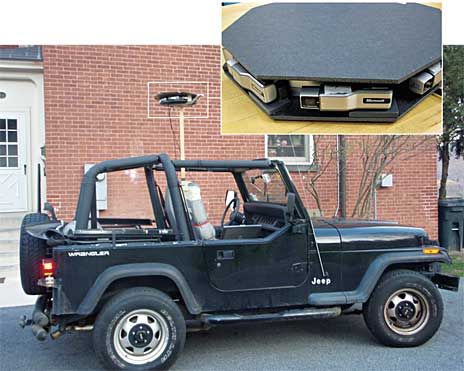
Create Google Street View-like panoramas with cheap webcams and open-source software

If you use Google Maps, you're probably familiar with its Street View feature, which shows actual ground-level photos of many cities around the world. Google creates the images by mounting special cameras on vehicles and driving them around.

Now wouldn't it be great if you could have your own Street View–like camera? You could hike a trail and later share the photos with friends. The photos would carry GPS tags, so you could display them on Google Earth and include annotations—good water here, poison ivy there. Realtors could display whole neighborhoods to potential clients. A country club could offer a virtual tour of its golf course. Architects could monitor progress at a construction site. [...]


JEEP CAM


SOFTWARE
UVC driver: http://linux-uvc.berlios.de
Webcam device driver: http://linuxtv.org
luvcview: http://www.quickcamteam.net
Exiftool: http://www.sno.phy.queensu.ca/~phil/exiftool
gpicsync: http://code.google.com/p/gpicsync
autopano-sift: http://user.cs.tu-berlin.de/~nowozin/autopano-sift
hugin: http://hugin.sourceforge.net
PTViewer: http://www.fsoft.it/panorama/ptviewer.htm


Read more: http://spectrum.ieee.org/geek-life/hands-on/diy-streetview-camera/0

30 Resources to Find the Data You Need


Ikke megen GIS data, men hjælp selv med til at gøre listen længere ...
/Sik


Not much GIS data here but you may add to the list ...
/Sik


Quote

[...]

Geographic Data

Got some mapping software, but no geographic data? You're in luck. There are plenty of shapefiles, etc. at your disposal.

DATA SOURCES:

  • TIGER - From the US Census Bureau, detailed data about roads, railroads, rivers, and zipcodes. Probably the most extensive you're going to find.
  • OpenStreetMap - One of the best examples of data and community effort.
  • Geocommons - Both data and a map maker.
  • Flickr Shapefiles - Boundaries as defined by Flickr users.

[...]


Read more: http://flowingdata.com/2009/10/01/30-resources-to-find-the-data-you-need/

Apple purchased Placebase in July to replace Google Maps?


Æblet falder kort fra stammen ...
/Sik


MApple ...
/Sik


Quote

On July 7th, Fred Lalonde, the founder of openplaces.organnounced in a tweet that Apple had bought the company that produced the Maps API that his company used in their software.

Pushpin is the name of the software API that Openplaces uses and it is made by a company called Placebase.

"Apple bought PlaceBase - all hush hush. Pushpin site taken offline. Hyperlocal iPhone?"

[...]

Yep, Apple bought Placebase. But what are they going to do with this software?

Placebase is similar to Google Maps in that it is a mapping service and has the world mapped out. You can zoom in and out and it has different layers you can superimpose over your mapping data. It does other things better than Google, however.

[...]

It may be a smart move for Apple to buy its way out of its dependency on Google now, while it has the chance. [...]


Read more: http://blogs.computerworld.com/14835/apple_purchased_mapping_company_in_july_to_replace_google