søndag den 31. maj 2009

North Korea's 2009 nuclear test: A geospatial roundup


Jeg er født i Sydkorea, men heldigvis adopteret - tænk sig at leve et sted med en nabo som Nordkorea? I 1983 gik jeg i den Internationale skole i Dar Es Salaam, Tanzania og havde blandt andet special undervisning i engelsk sammen med en nordkoreaner - og heldigvis er det jo sådan at når man står over for det enkelte individ så er vi alle sammen almindelige mennesker med de samme interesser og intentioner ...
/Sik


I was born i South Korea but fortunately adopted - image living in a place where there exists a neighboor like North Korea? In 1983 I was a pupil in the International School in Dar Es Salaam, Tanzania and there I attended special classes in english along with a north korean boy - fortunately when meeting people face to face in daily life we are all alike and share the same interests and intentions ...
/Sik


Quote

On May 25, 2009, North Korea performed a second underground test of a nuclear explosive. The first test had taken place on October 9, 2006, and resulted in several KML files pinpointing the suspected location of the test. What follows is round-up of the public geospatial intelligence gathered this time around. Where relevant, I'vecollected the information into this KMZ file. All content is attributed to its original sources. 

dprkroundup.jpg

The RozTracker - Rowing Across the Pacific Ocean


Jeg bliver helt øm i armene (og resten af kroppen) bare ved tanken ...
/Sik


You really gotta like rowing and being alone by yourself ... Though girl!
/Sik


Quote

Roz Tracker

The RozTracker is an interactive map that you can use to track Roz's progress across the Pacific, and see exactly where she was when she posted updates to Blogger, Twitter, YouTube, Flickr and iTunes. It takes data from Roz's Solara Field Tracker GPS system and links it to her postings to show the trail of rich social media content she leaves as she rows across the ocean. Click on the Roz icon to see how fast Roz has been rowing, how far she's gone, and how close she is to various islands around the Pacific Ocean. The Graphs button allows you to display various parameters and choose a date range so you can evaluate Roz's voyage statistics. The Journal button shows a news feed of all Roz's social media postings in date order. The RozTracker uses Google Maps and was developed byArchinoetics based on technology it developed for Project Niu, a K-12 education program to teach students about ocean science, technology, and stewardship. [...]

Source: Microformats.dk by Søren Johannesen

Read more: 

lørdag den 30. maj 2009

Geologic Time: Graphical Representation of Geologic Time


Universet, jorden , livet på jorder, mit liv på jorden ...
/Sik


The universe, the Earth, live on Earth, my life on Earth ...
/Sik


Quote

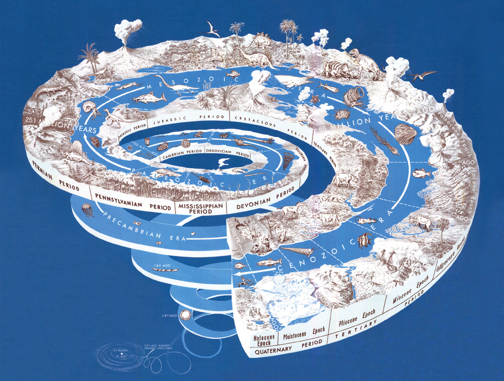
Diagram showing geologic time

The Earth is very old -- 4.5 billion years or more according to recent estimates. Most of the evidence for an ancient Earth is contained in the rocks that form the Earth's crust. The rock layers themselves -- like pages in a long and complicated history -- record the surface-shaping events of the past, and buried within them are traces of life --the plants and animals that evolved from organic structures that existed perhaps 3 billion years ago.

Also contained in rocks once molten are radioactive elements whose isotopes provide Earth with an atomic clock. Within these rocks, "parent" isotopes decay at a predictable rate to form "daughter" isotopes. By determining the relative amounts of parent and daughter isotopes, the age of these rocks can be calculated.

Thus, the results of studies of rock layers (stratigraphy), and of fossils (paleontology), coupled with the ages of certain rocks as measured by atomic clocks (geochronology), attest to a very old Earth! [...]

Source: Smashing Magazine


Read more:  http://pubs.usgs.gov/gip/geotime/time.html

Diamond mines visible from space


Diamanter varer evigt ...
/Sik


Diamonds are forever ...
/Sik


Quote

Click stars to vote
Subscribe to our API RSS FeedComment on this MashupReport Broken Link

Description

Google Map mashup of diamond mines as seen from space. Click through next and prev to browse through the spectacular view of diamonds mines from 30000 ft above earth.

APIs
Google Maps Flash
Tags
Added
24 May 2009
Who
marksteve_74 [Profile]
URL
http://www.jewelinfo4u.com/Di ... 


Source: Programmable Web

Read more: 

Satellite Detects Red Glow To Map Global Ocean Plant Health


Plankton ... så småt og så aligevel så stort når blot at der er mange nok ... En stor del af jordens biomasse er bundet i plankton så det er nok en god ide at holde et skarpt øje med tilstanden disse små kræ ...
/Sik


Plankton ... so small and yet so big when all combined ... A large amount of the earth bio mass is contained within these small creatures and keeping an eye on their well being might be a good idea ...
/Sik


Quote


Researchers from Oregon State University, NASA and other organizations said today that they have succeeded for the first time in measuring the physiology of marine phytoplankton through satellite measurements of its fluorescence – an accomplishment that had been elusive for years.

With this new tool and the continued use of the MODIS Aqua satellite, scientists will now be able to gain a reasonably accurate picture of the ocean's health and productivity about every week, all over the planet.

Data such as this will be critically important in evaluating the effect on oceans of global warming, climate change, desertification and other changes, the researchers said. It will also be a key to determining which areas of the ocean are limited in their productivity by iron deficiency – as this study just showed the Indian Ocean was. [...]

Source: The Map Scroll


Read more: http://www.sciencedaily.com/releases/2009/05/090528135242.htm

fredag den 29. maj 2009

Where 09: Dan Gillmor, "Where Does Journalism Go?"


Anvendelse af GIS og kort i nyhedsformidlingen ...
/Sik


Using GIS and maps in journalism ...
/Sik


Quote


Dan Gillmor (Arizona State University's Cronkite School of Journalism & Mass Communication) "Where Does Journalism Go?"

Source: GeoJournalistik.dk by Jesper Ishøj

Read more: http://where.blip.tv/file/2163545/

Thematic Maps - Up2Maps


Endnu en spændende tematisk mapper med mange muligheder ... 
/Sik


Yet another thematic mapper filled with many great tools ...
/Sik


Quote


Create Thematic Maps Fast with Up2Maps

Feature List
:
  • Maps can be exported to image (png) or embedded in blogs.
  • Data can be uploaded in excel files or typed directly in the application.
  • There are 2 levels of detail for each country.
  • Runs on Google Maps Flash API
  • Data includes territory names, zip/postal codes and international codification like FIPS and ISO.
Source: Mapping News by Mapperz

Read more: http://www.up2maps.net/#polygonId=WLD;zoom_level=0

See Google Wave in Action (Video)


Mail + Chat + Realtime = Wave 
/Sik


Mail + Chat + Realtime = Wave
/Sik


Quote


Google Wave Developer Preview presentation at the Day 2 Keynote of Google I/O. To learn more visithttp://wave.google.com

Source: Google Blogoscoped

Read more: 

3D tours added to the Google Earth Gallery


Google Earth Tour værktøj er lige så smart som det er simpelt ...
/Sik


The Google Earth Touring tool is simple yet powerful in it's simplicity ...
/Sik


Quote

If you're a 3D enthusiast, then you'll probably enjoy the latest addition to the Google Earth Gallery: 3D Buildings. This new category provides a number of self-running tours on various themes. The tours showcase some fascinating 3D buildings (along with bridges and statues and other structures) around the world, most of which were built by our passionate Google SketchUp users who model buildings for Google Earth. Whether your interest is castles,bridgesmuseumsbaseball stadiums or skyscrapers, I think you'll find a self-guided tour that is of interest to you.


The tours were developed by geo-modelers Adam and Jordan, both of whom are 3D experts who really know their way around Google Earth.


To play a tour, simply click on the "Open in Google Earth" link to download the KML file. Then click the "Start tour here" link in the "Places" panel in Google Earth (download the latest version of Google Earth). Make sure the "3D Buildings" layer is checked in the "Layers" panel. The tour will pause at each location to ensure the 3D building is fully loaded. Click the play button to continue the tour. Enjoy!


Read more: http://google-latlong.blogspot.com/2009/05/3d-tours-added-to-google-earth-gallery.html

Danskernes post og NemSMS lander hos eBoks


Det var også på tide ... Digital kommunikation med det offentlige ...
/Sik


Only Danish
/Sik


eboks_logo
Quote

I dag skriver Økonomistyrelsen under på en aftale om NemSMS og den fælles dokumentboks for det offentlige med eBoks. Næste år kan alle danskere få post og sms direkte fra det offentlige.

Af Send e-mail Mads Bang

En sms fra sygehuset tikker ind på mobilen aftenen før, du har en aftale med en speciallæge, og det er slut med rudekuverter fra det offentlige - det hele lander digitalt i dokumentboksen på Borger.dk - og du får besked pr. sms. 

Det er et scenarie, der bliver virkelighed næste år, hvis alt går som forventet, efter Økonomistyrelsen nu har valgt eBoks som leverandør af NemSMS og den digitale dokumentboks.

Street View Strøget mm.


En lille forsigtig start på en street view applikation på dansk jord ... Håber at den kommer til at dække mere end de få gader der pt. er på  ...
/Sik


A small (but hopefully growing) street view app covering parts of Copenhagen ...
/Sik


Quote


Gadefoto have released a street view type product for Copenhagen in Denmark. The site seems to be using TeleAtlas for the mapping part of the application
Source: Google Maps Mania

torsdag den 28. maj 2009

Check out the developer preview at Google I/O


Minder mig om en bog jeg læste i gymnasiet: The Wave ... 
/Sik


Reminds me of a book I once read: The Wave ... 
/Sik


Quote

Google Wave is a new tool for communication and collaboration on the web, coming later this year. Watch the demo video below, sign up for updates and learn more about how to develop with Google Wave.

Google Wave will be available later this year.

Learn
Google Wave can make you more productive even when you're having fun.
Take a sneak peek.

Develop
Learn how to put waves in your site and build wave extensions with the Google Wave APIs.
Visit code.google.com/apis/wave.

Build
Google Wave uses an open protocol, so anyone can build their own wave system. 
Learn more at www.waveprotocol.org.

Source: ProgrammableWeb

Read more: http://wave.google.com/

Microsoft Virtual Earth Now “Bing maps for Enterprise”


Bing Maps ... Det skal man lige vænne sig til ...
/Sik


Bing Maps ... MapBings ...
/Sik


Quote

Microsoft today announced the release of its new search engine, Bing. As part of this, the Virtual Earth mapping platform and the Live Search Maps consumer site for location-based search and mapping that Virtual Earth powers will be rebranded as “Bing maps for Enterprise” and “Bing maps,” respectively.


Bing is coming ...


Først kom Wolfram|Alpha og nu kommer Microsoft Bing ... 
/Sik


Recently Wolfram|Alpha and now soon Microsoft Bing ...
/Sik


Quote


Microsoft Corp. today unveiled Bing, a new Decision Engine and consumer brand, providing customers with a first step in moving beyond search to help make faster, more informed decisions. Bing is specifically designed to build on the benefits of today’s search engines but begins to move beyond this experience with a new approach to user experience and intuitive tools to help customers make better decisions, focusing initially on four key vertical areas: making a purchase decision, planning a trip, researching a health condition or finding a local business. The result of this new approach is an important beginning for a new and more powerful kind of search service, which Microsoft is calling a Decision Engine, designed to empower people to gain insight and knowledge from the Web, moving more quickly to important decisions. The new service, located at http://www.Bing.com, will begin to roll out over the coming days and will be fully deployed worldwide on Wednesday, June 3. [...]

Source: GISUser.com

Read more: 

Google Apps Script: Expanding the Google Office With Your Own JavaScript


Se også http://gisdk.blogspot.com/2009/05/google-tests-scripting-feature-for.html
/Sik


Also see http://gisdk.blogspot.com/2009/05/google-tests-scripting-feature-for.html
/Sik


Quote

[...] According to the intro page, with scripts you can:

  • “Create your own custom spreadsheet functions”
  • “Automate repetitive tasks (e.g. process responses to Google Docs forms)”
  • “Link multiple Google products together (e.g. send emails or schedule Calendar events from a list of addresses in a Spreadsheet)”
  • “Customize existing Google products (e.g. add custom buttons or menus to run your own scripts)”
   

Read more: http://blogoscoped.com/archive/2009-05-28-n50.html

Han vil revolutionere folkestyret med web 2.0


Det skal blive spændende at se ... det bringer i hvert fald folket og politikerne tættere på hinanden ... fremmedgørelsen vil blive mindre begge veje ... Dog vil det i første omgang kun være de 'socialt' bevidste som vil 'kunne' spille med ...
/Sik


Only Danish
/Sik


Quote

En ung dansk programmør gør, hvad folketinget.dk indtil videre ikke har formået. Han inddrager borgerne, der kan følge deres politiker tæt og kommentere lovforslag.

Hold øje med, om politikeren, du stemte på ved valget, også varetager dine interesser. Kommentér lovforslag og diskutér dem med andre brugere. 

Det er nogle af de muligheder, det nye site Folkets Ting byder på. 

Bag siden står den 27-årige studerende fra IT-Universitet Michael Friis, som mener, det er på tide, at folkestyret også inddrager borgerne på nettet. En opgave, som han ikke mener, at Folketingetsofficielle side har løftet tilfredsstillende endnu. 

"Jeg var frustreret. Internettet er jo fedt til at inddrage borgere og brugere, og Folketinget.dk har alle afstemningsresultater, tekster og lovforslag, så det er da oplagt at folk skal have lov til at svare igen," siger Michael Friis.  [...]


Read more: 

How to use Mapstraction


Hvordan du anvender Mapstraction ...
/Sik


How to use Mapstraction ...
/Sik


Quote

By Andrew Turner


Tutorials on Hacking Map API's, OpenData formats, Mapstraction and more given at Where2.0 2009.

Source: ProgrammableWeb

Read more: http://www.slideshare.net/ajturner/hacking-map-apis-workshop-where20-2009?src=embed