tirsdag den 31. marts 2009
Kommunikation med kort - Informationsdesign og visualisering

Kommunikation med kort – informationsdesign og visualisering beskriver, hvordan man udnytter kort bevidst til at styrke ens budskab, og hvordan man analyserer brugen af kort og fremstiller dem grafisk.
Kommunikation med kort – informationsdesign og visualisering indeholder såvel teori som utallige grundige ek sempler fra dagligdagen, tips og tricks samt ”hot or not”. Eksemplerne knytter metoder og virkeligheden sammen.
Kommunikation med kort – informationsdesign og visualisering er opfølgeren til Lars Brodersens bog Kort som kommunikation fra 1998, der var den første danske bog om kartografi og kommunikation. I forhold til forgængeren er alle emner her behandlet betydeligt grundigere med bedre teori og metode og med mange praktiske eksempler, og der er tilføjet nye emner, eksempelvis værdimodellering og meget mere om udtrykket.
Buy: http://nyttf.dk/?pagetype=book&vareid=84003-1
“Is Google Good for Geography?” “Is Microsoft Better for Geography?”

Hvor er geo webben på vej hen? På vej hen til dig og mig?
/Sik

In what direction is the geoweb going? In yours or mine?
/Sik
Quote
March 31st, 2009by Sean Gorman
Last week was a bit of a roller coaster starting in Las Vegas for the American Association of Geographers annual meeting and ending at Gov20Camp in Washington DC. In many ways the 2009 AAG meeting was a coming out party for the GeoWeb. There was a critical mass of presentations - well over twenty, and several respected figures discussing the GeoWeb’s impact on the traditional study of geography. Mike Goodchild’s talk onVolunteered Geographic Information (VGI) was packed and focused on the impact of several GeoWeb innovations ranging from OpenStreetMap to geotagged Flickr photos. Much of Goodchild’s work has been focused on the rigor (metadata, ground truthing etc.) of VGI, which despite skepticism is emerging with surprising levels of accuracy. [...]

Read more: http://blog.fortiusone.com/2009/03/31/notes-from-the-aag-is-google-good-for-geography-is-microsoft-better-for-geography/
Map It Out provides several ESRI ArcGIS Server 9.3 tools available as a free download
For godt til at være sandt?
/Sik
Too good to be true?
/Si
- Area and Buffer Selection Tool
Draw a polygon or define a buffer to select features, and view their attributes. - Bookmark Tool
Add bookmarks to easily revisit extents at a later point in time. - Hyperlink Tool
Open link to images, documents, and web pages by clicking on features in a layer.
- Export Tool
Export one or more visible layers to a shapefile.
- Custom Query Tool
Design and execute powerful ad-hoc queries to view features and their attributes.
Click here to download the tools in a single package.
Read more: http://www.mapitout.com/products.htm
GIS-baseret national vej- og trafikdatabase 1960 - 2005
Læs historien bag vejnettet i KMS' Kort 10 DK ...
/Sik
Only Danish
/Sik
Quote
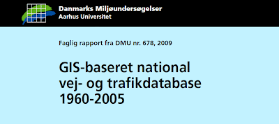
Read more: http://www2.dmu.dk/Pub/FR678.pdf
mandag den 30. marts 2009
Flightmapping's Airline Route Maps
Peg på en by og se hvilke afgange der findes og hvortil ...
/Sik
Point at a city and see where you can fly to from there ...
/Sik
Quote
Read more: http://www.flightmapping.com/
lørdag den 28. marts 2009
Impressions from 2009 ESRI Business Partner Conference
En grundig gennemgang af dette års vel overståede ESRI konference i Palm Springs ...
/Sik
A comprehensive report from this years ESRI conference in Palm Springs ...
/Sik
Quote
Stu Rich
[...]
ArcGIS Explorer build 900 - OK so this is the one really sexy piece of technology that will be released in conjunction with the 9.3.1 product suite. ArcGIS Explorer build 900 represents a revolutionary step change in geospatial viewers. Until now, ArcGIS Explorer (AGX) seems to have been struggling to keep pace with Google Earth (GE) and as new capabilities were released in GE the AGX team would try to release something comparable. The release of build 900 turns that whole dynamic on its head. This release shows great vision. To begin with, AGX 900 explodes the “geospatial bookmark” concept and provides a wonderful blend of geospatial viewer with presentation tool. Think MS PowerPoint on steroids. You can create a whole presentation that is based on a sequence of spatial bookmarks with associated data sources with the appropriate cartography so that you can really tell a compelling story with the tool. In the hands of an already gifted story teller like Bernie Szukalski (AGX product manager) the product just sings. Additionally, you can package up any of the “slides” in your story (essentially a spatial perspective along with a package of cartography and data sources) and email that “slide” as a “Layer Package” to anyone else in your community so that they can see your specific visualization of the problem. Finally, you can easily alternate between a 2D and 3D visualization of your problem in a highly optimized rendering experience. The demonstrated end-user experience was tremendous. I can’t wait to get my hands on the Beta. Jeff Jackson and Andy McDonald have really outdone themselves with AGX 900 proving that product innovation and creativity are repeatable qualities given the right organizational environment.
ArcGIS Server Performance. It is no secret that ArcGIS Server has earned itself a poor reputation when it comes to performance. There are a lot of ESRI customers that have refused to migrate off of their ArcIMS installations only because ArcIMS has consistently out-performed ArcGIS Server. As my friend Steve Segarra likes to say, “there is nothing more important in software architecture design than elegance…. except performance”. The ArcGIS Server team seems to have taken performance very seriously with this release. I witnessed time and again sub-second refresh rates from ArcGIS Server with the kind of attractive cartography that you have come to expect from ArcGIS Server. I will reserve final judgment until I get my hands on the final product, but my initial look at the new performance is very encouraging.
Microsoft Silverlight ADF. Last year ESRI got serious about supporting Adobe FLEX and now has a very mature FLEX ADF available for FLEX developers. We have been Flash/FLEX developers for some time and love the work that Mansour and his team are doing with the FLEX ADF. The addition of MS SilverLight to the family of ESRI application development frameworks presents some interesting new opportunities. I think that for MS-specific server products like Exchange and Sharepoint, the availability of MS Silverlight to the arsenal may open up some interesting opportunities.
[...]
Read more: http://spatialexplorations.net/2009/03/28/impressions-from-2009-esri-business-partner-conference/
Create your own mapped Google Street View tours - embed onto your website
Lav dine egne guidede ture rundt i verden ... hvis der altså er Street View dækning ...
/Sik
Make your own guided tours around the world ... if you have Street View coverage ...
/Sik
Quote
Read more: http://www.mashedworld.com/Home.aspx
Guide to the G20 Summit
Mouse over og bliv informeret ...
/Sik
Mouse over and get informed ...
/Sik
Quote
Read more:
eKvittering er klar til test
I juli måned sidste år nævnte jeg dette koncept: http://gisdk.blogspot.com/2008/07/f-styr-p-dine-kvitteringer.html. Når du handler bliver din kvittering gemt digitalt til senere brug ...
Only Danish ...
/Sik
Quote
Så blev vi klar!
 Nu starter testen af eKvittering. Testen løber frem til lanceringen af eKvittering, og i perioden er vi meget interesseret i, løbende at høre om dine erfaringer med eKvittering. Dette gør vi for, at kunne give dig og andre bruger den bedste oplevelse med eKvittering. Vi vil derfor, via et elektronisk spørgeskema, bede om dine erfaringer og bemærkninger. Kan du ikke vente på, at vi får sendt spørgeskemaet ud, er du altid velkommen på vores e-mail adresse info@ekvittering.dk
Butikslisten vil løbende blive opdateret med nye butikker, så du får flere muligheder for at få kvitteringen elektronisk. Du kan følge opdateringen her .
For at oprette en konto, skal vi bruge enkelte oplysninger om dig, og din accept af vores handelsbetingelser - også selvom du får eKvittering gratis.
Husk at brug samme e-mail adresse, som denne e-mail er sendt til.
Når du har gennemført oprettelsen sender vi en e-mail, hvor du vil blive bedt om at aktivere din konto. I samme e-mail får du også dine adgangsoplysninger. Efter aktiveringen kan din konto benyttes. Gå ind på test.ekvittering.dk og log dig ind via boksen i venstre side.
Når du har handlet i en butik med eKvittering, vil kvitteringen være fremme i din personlige indbakke i løbet af 24 timer, og ofte før. Er kvitteringen ikke dukket op efter 24 timer, vil vi meget gerne høre fra dig via vores formular "kvitteringsfejl", som du finder under menupunktet "HJÆLP" i menuen til venstre. Det er med andre ord en god idé, især under testen, at gemme papirkvitteringen indtil du har konstateret at den ligger i din indbakke.
Som en hjælp indekserer vi dine kvitteringer automatisk i foruddefinerede mapper. Dette betyder at et indkøb i en forretning med udelukkende sports- og fritidsartikler vil havne i mappen "Sport & Fritid".
Vi glæder os meget til at se dig på test.ekvittering.dk og høre om dine oplevelser med eKvittering.
Venlig hilsen
fredag den 27. marts 2009
Searching for more than the point
Nu indekserer Google dine kort ... fremover må du forvente at også andre end dig og dine venner vil se dine kort ...
/Sik
Google has started indexing your Google maps ... from now on it is no longer just you or your friends watching your maps ...
/Sik
Quote
Over the past few years Google Maps users have created millions of maps using the My Maps feature. At the same time we have been busy scouring the web to find maps in other formats, like KML and GeoRSS, to include in our index. As you may have seen in the recent post about blended search results we have been including individual places from those maps in our results. Until now, however, there has been no easy way to find complete maps created by others. That changes this week, as we start to surface a link to these complete maps when we think they are relevant to your query. [...]
Read more: http://google-latlong.blogspot.com/2009/03/searching-for-more-than-point.html
Moving Toward an Open Process on Cloud Computing Interoperability
En sky er en sky er en sky ...
/Sik
A cloud is a cloud is a cloud ...
/Sik

Quote
[...] Recently, we've heard about a “Cloud Manifesto,” purportedly describing principles and guidelines for interoperability in cloud computing. We love the concept. We strongly support an open, collaborative discussion with customers, analysts and other vendors regarding the direction and principles of cloud computing. When the center of gravity is standards and interoperability, we are even more enthusiastic because we believe these are the key to the long term success for the industry, as we are demonstrating through a variety of technologies such as Silverlight, Internet Explorer 8, and the Azure Services Platform. We have learned a lot from the tens-of-thousands of developers who are using our cloud platform and their feedback is driving our efforts. We are happy to participate in a dialogue with other providers and collaborate with them on how cloud computing could evolve to provide additional choices and greater value for customers.
We were admittedly disappointed by the lack of openness in the development of the Cloud Manifesto. What we heard was that there was no desire to discuss, much less implement, enhancements to the document despite the fact that we have learned through direct experience. Very recently we were privately shown a copy of the document, warned that it was a secret, and told that it must be signed "as is," without modifications or additional input. It appears to us that one company, or just a few companies, would prefer to control the evolution of cloud computing, as opposed to reaching a consensus across key stakeholders (including cloud users) through an “open” process. An open Manifesto emerging from a closed process is at least mildly ironic. [...]
Read more: http://blogs.msdn.com/stevemar/archive/2009/03/26/moving-toward-an-open-process-on-cloud-computing-interoperability.aspx
Setting Up Google Earth Options
FYI
/Sik
FYI
/Sik
Quote
If you're wondering what Google Earth experts do to make things run faster or better, then read this article. This blog entry describes tips on how to set up your Google Earth 5 options ("Preferences" on the Mac). These options can greatly improve your experience with Google Earth by optimizing important graphics and data constraints, speeding up certain actions, or improving the quality of your views.
To get to the GE options, select the menu "Tools -> Options" (or "Google Earth -> Preferences" on the Mac). This opens a window of options with the following panes: 3D View,Cache, Touring, Navigation, General. [...]

Read more: http://www.gearthblog.com/blog/archives/2009/03/setting_up_google_earth_options.html
Cartifact Maps (Beta) Cartographic Maps made available with Cartfact Labs and Google Maps API


Google Docs Gets a Drawing Program
Det måtte jo komme ...
/Sik
Go figure ...
/Sik
Quote
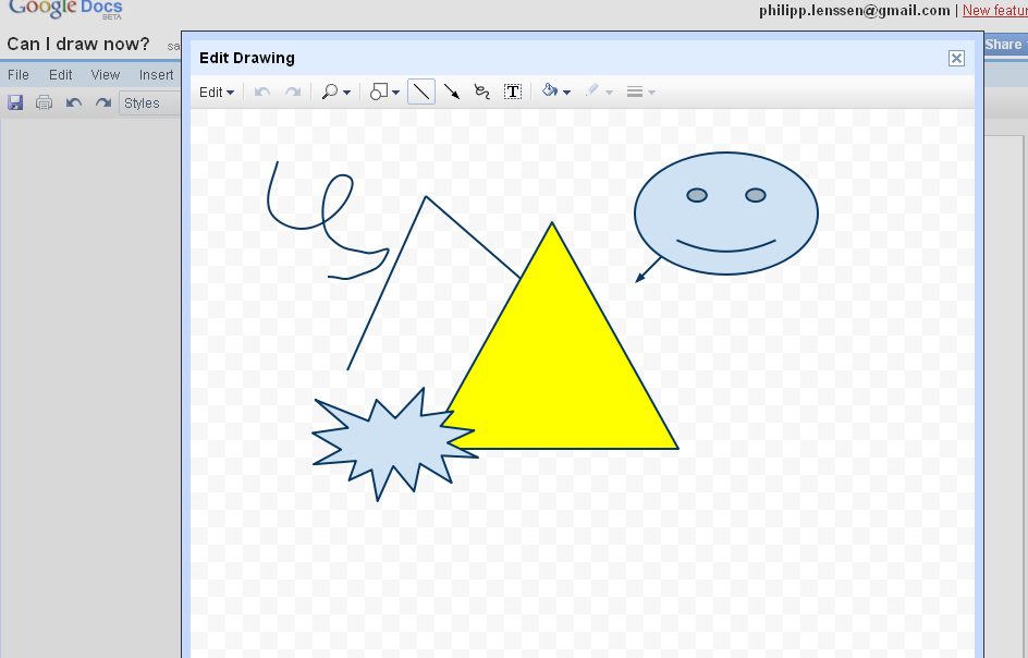
The Google Docs suite with its text, spreadsheets and presentation editors got a new tool: a vector drawing program. You may remember Tony hinted at this possibility here last month. You can try this feature by opening a new Google Docs document and clicking Insert -> Drawing. This will pop up an on-page window with a drawing canvas to which you can add things like lines, text, arrows, or shapes from a small object selection. The editor works very well, and you can flexibly adjust adjust colors, position, and size. Saving is done by hitting the X in the top right (that might be a bit odd, the first time), and then the drawing is integrated in your document (and can be edited once again later on if you want).
Google in a blog post gives a bit of background: [...]
Read more: http://blogoscoped.com/archive/2009-03-26-n63.html
Using Open Layers With Arc Gis Server Rest Api Dev Summit
På mange måder en inspirerende præsentation ...
/Sik
In many ways an inspiring presentation ...
/Sik
Quote
Looking Forward to a New Era in Web GIS
Ville Web 2.0 have været det samme uden GIS?
Would Web 2.0 have been the same without GIS?
/Sik
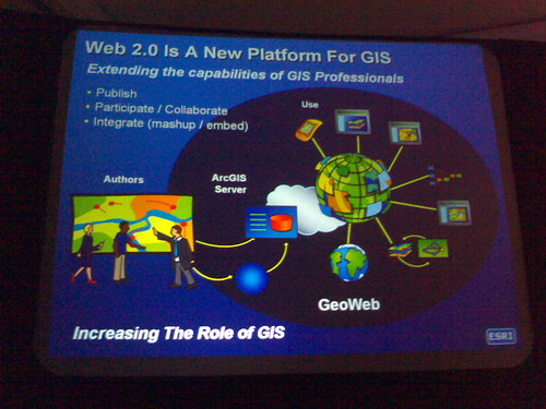
Quote
When you think about the sheer number of Internet-based mapping applications being developed and distributed, it's clear that the public's interest in maps is at an all-time high. At the same time, awareness of the value of spatial intelligence is growing rapidly among government leaders and private sector executives. This is all good—as a GIS professional, you're in the map business and you understand better than anyone the value of spatial intelligence for informed decision making.
Still, getting a mandate to deploy a GIS-enabled Web mapping application can be challenging. The average GIS professional working today didn't learn how to create Web applications as part of their degree program.
In a recent ArcNews Online article, Jack Dangermond, ESRI founder and president, articulates his vision of the future of GIS on the Web, or Web GIS. Dangermond says:
Web GIS harnesses the power and reach of the Web and integrates the rich knowledge resources of GIS—authoritative databases, models, and spatial analysis. Web GIS goes far beyond simple visualization and mapping and provides access to full geographic knowledge to everyone. Over time, Web GIS will become an essential part of the infrastructure of society. |
Dangermond believes GIS professionals will play a key role in building this infrastructure.

[...]
Read more: http://blogs.esri.com/Support/blogs/esritrainingmatters/archive/2009/03/05/looking-forward-to-a-new-era-in-web-gis.aspx
Imagery and GIS: Integration Now, Integration in the Future
Spørgsmålet er om ikke www hele tiden har været GIS? Bare uden billeder til at begynde med ... men nu en uundværlig del af det hele ...
The question is if not the www all along has been GIS? The images just weren't there in he begining ... but now not to live without ...
/Sik

Quote
We've all heard a picture is worth a thousand words, but GIS users know that image data (imagery) is priceless for understanding what is going on in the world and how the world is changing. From emergency planning and disaster response to environmental monitoring, the applications in which imagery plays a starring role are numerous and the demand for high-resolution imagery continues to grow, especially as the price for storage media continues to fall.
Typically, imagery workflows have occurred outside the GIS. But integration of imagery and image analysis workflows as a core component of an enterprise GIS system has been a hot topic lately.
In a recent interview published in GEOconnexion International magazine, Lawrie Jordan, ESRI director of imagery enterprise solutions, shared his thoughts on the future of imagery and enterprise GIS. Jordan says, "The integration of imagery into the core of GIS is a key strategic direction that we will see being taken in the future."
"Hard to get, hard to use, and very expensive"
[...]
Read more: http://blogs.esri.com/Support/blogs/esritrainingmatters/archive/2009/03/18/imagery-and-gis-integration-now-integration-in-the-future.aspx