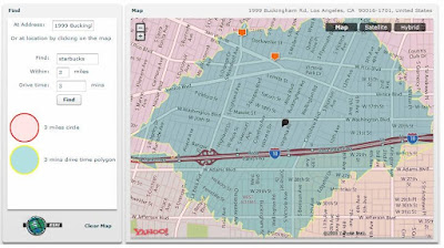
Flex GeoWeb Demo with Y!Map for AS3, ESRI and JavaScript
Posted by Moxie April 11, 2008 .
On April 11, 2008, Inside RIA featured my article, demonstrating how to program in Flex for GeoWeb applications. The article, entitled “Flex GeoWeb with Yahoo AS3,” contains some good coding explanations. You can access the demo application that hosted at Flex888, right click on Flex to view the Flex and JavaScript source code.
As those with expertise in architecture, enterprise systems and solution development know, Web 3.0 is all about turning information into data, processing the data into knowledge, and then applying knowledge in ways that benefit people’s lives. What many may not know is that 80 percent of the data/information collected, in business and personal applications, contains spatial information. This may be why the Web map giant Google proudly uses the terms “Web 3.0″ and “GeoWeb.” Now, the question is, are we (or is Google) really ready for Web 3.0 GeoWeb?
Before answering that question, let’s look at the nature of the data. All data essentially answers the four Ws–what, who, when, where and how. They are the foundation of all knowledge as well. Over the past several decades, IT professionals have expended a lot of efforts and resources to fine tune RDBMS for handling data. The most representative technology is data warehouse, which uses dimensional modeling to look/search/analyze data in many angles (dimensions). However, regardless of how many dimensions are created to mine the data, they are all variations of answers to the four Ws. The “where” part is simply another aspect of “what.”
This is why people are so crazy about Google Map, and 90 percent of mashups are Web- map based. The “where” part of information is not just another piece of data in the SQL; it’s becoming meaningful and has true value on the map. Does that mean we are ready for Web 3.0 GeoWeb? No, and we will not be ready until we can go beyond visualizing the “where” data to get a better understanding of the spatial information.
What is spatial information? If you answered it is “location,” you are 95 percent wrong.
To get an idea of the magnitude of spatial information, we can think of streets, the most familiar entities on a Web map. What is street data in a database? There are data that represent segments of a curved line or polygon that can be visualized; there are data that can help draw the line/polygon on the right place on the map; there are data that define how those lines/polygons are connected, or how certain lines cross over another lines (bridge overheads); and there are data for symbols and annotations that tell you what the streets are. In addition, there are more complex data structures to represent houses, buildings, parks, lakes and other objects. This list can go on an on. In addition, each single item mentioned above can be modified individually, while maintaining the logic of how it relates to other data (intersection, connection, ramp, overhead, one-way, two-way, etc). If you are a data architect or a DBA, your mind must be spinning thinking of how those data can be modeled and managed. Like me, you are probably thinking, “It’s hard.” What I can tell you is that a street network is considered one simple type of spatial data. How about electric grid, gas lines, water pipes and so on?
Next, one might ask how to process and analyze the spatial information. This requires a Spatial Information Management (SIM) platform and related services. Enterprise professionals are very familiar with the three-letter soup: ERP to manage resources, CRM to manage customer relationships, SCM to manage supply chain, EAM to manage assets, PDM to manage product data, PLM to manage product lifecycle, and now SIM to enable spatial services and manage spatial information. This helps to extend all other three-letter enterprise systems into true spatial dimension. We can’t move past the location visualization phase (as Google Map does) into Web 3.0 without SIM. Of course, spatial information is only a small portion of all information available. Therefore, we have a long way to go with Web 3.0.
A SIM platform contains solutions, services, tools, data management and programming technologies, just like the ERP. If you’ve heard of the geographic information system (GIS) you are close enough to knowing a bit about SIM. GIS provides all the tools and technologies to support the SIM platform. For example, a GeoDatabase, which can be built on top of traditional RDBMS, is for managing the spatial information mentioned earlier. GeoDatabase management handles all the complexity for you. In addition, GeoProcess helps process spatial data by applying scientific and mathematical theory. It’s essentially done for most IT professionals. We can use the common IT technologies, programming, Web services, SOA, .Net, and J2EE to make IT services spatially rich and add long-missed spatially enabled value to business applications.
Now that Geo spatial technology is about to take off in both broader enterprise and Web space applications, owing to the maturity of SIM, most IT professionals will be able to move beyond putting push-pin on a giant Web map.
Ingen kommentarer:
Send en kommentar