Den anden dag diskuterede jeg med en kollega om hvad Cloud Computing er for en størrelse ... Hvad kan man med skyen (som ikke allerede kan lade sig gøre idag)? Hvad kan brugerne af en sky-applikation forvente sig? For at være ærlig kunne jeg ikke give et klart svar ... Det kunne kun blive til formodninger og gætværk ... Ligesom Internettet i sig selv er et koncept ved hjælp af hvilket man kan GØRE ting - hvad du gør er ikke meget anderledes end hvad man hele tiden har gjort, men måden hvorpå du gør det er (ofte) meget anderledes. Skyen er en arkitektur, et design, det er en ide og sidst men ikke mindst er den et 'mode' fænomen på linje med Web 2.0. Sidstnævnte er kommet for at blive kan vi alle være enige om, men hvad er det? Vi anvender alle navnet i flæng, mange tror de ved hvad det er, men de fleste kan ikke give en klar definition ... Skyen er derude, men vi kan ikke se den, så er den der virkelig?
/Sik

I had a discussion the other day with a colleague about Cloud Computing ... What IS the Cloud? What can be done with the Cloud (not already possible before the Cloud)? What can users expect from the Cloud? Honestly I had no clean answers - just hints and guesses ... Like the Internet the Cloud is a concept in which you DO things - what you do is more or less the same as before - but how you do it is (some times) fundamentally different. The Cloud is an architecture, it's a design - it's an idea and last but least it's a buzz just like Web 2.0 ... The latter is here we all can agree but what is it? We all use the term, many think they know but the fact is only a few can define it ... The Cloud is out there but you can't see it ... so is it really there?
/Sik

Quote
Highlights
- On-demand access to cloud services is part of working with ArcGIS.
- ArcGIS users will be able to access full GIS capabilities in the cloud.
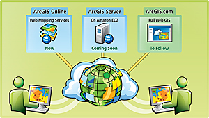
- Coming soon, ArcGIS Server will be in the Amazon cloud.
Cloud computing is viewed as the next evolution that will impact businesses and how they manage their IT infrastructures. Cloud computing has a direct impact on GIS and GIS users. ESRI has already been leveraging cloud computing resources for a number of years and, in the coming months, will offer additional products for direct use in the cloud. ESRI's emerging cloud-ready strategy is to provide customers with a range of opportunities for choosing the most efficient, cost-effective, and secure mix of on- and off-premises GIS applications and services to meet their business needs.
 In 2010, ArcGIS will deliver a growing selection of online services and software. |
ArcGIS in the cloud makes it possible to take advantage of the benefits of cloud computing, including deployment of Web 2.0 applications that require flexible scalability. ArcGIS Server and ArcGIS Online provide new, cost-effective, and flexible opportunities for organizations to deliver and consume GIS content and services in the cloud. Using ArcGIS in the cloud shifts the duty of maintaining on-premises resources to the cloud vendor, alleviating the customer's responsibility for maintenance and support.
A Complete Online GIS
The road map for ESRI's cloud-based GIS offerings includes access to full GIS capabilities in a cloud environment. This will include authoring, analysis, geodata management, hosting Web services, and applications. ESRI sees cloud-based GIS as a key aspect of any GIS system moving forward. Some aspects of this are available now, and more will be available over time. Over the next year, ESRI will systematically release capabilities and components in a fully integrated system.
Users Take Advantage of the Cloud with ArcGIS Online
Many ArcGIS users are already interacting with on-demand cloud services as part of their normal GIS workflow. These services are built into ArcGIS software with ready-to-use high-quality imagery and topographic and street basemaps, as well as routing and geocoding services for North America and Europe. This system allows users to access and apply these maps and the most current available data and functions without the expense and labor of developing and maintaining this information in-house.
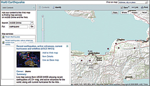
 Example of recent Haiti Earthquake interactive Web map shared via ArcGIS Online. |
ArcGIS Online also allows users to share their maps and data and collaborate with others who have a common interest. Users can create and join groups and upload items to share. They can control access to their own data, either making it available only to certain groups or sharing it publicly. This system allows GIS users to collaborate on joint projects and quickly share their GIS work within specific communities. ArcGIS Online includes content published by ESRI, other GIS users, and commercial data vendors. It also includes a Web map application for visualizing shared services and creating mashups without any programming. Developers can also access ArcGIS Web Mapping APIs through ArcGIS Online.
ArcGIS Server on the Amazon Cloud
Increasingly, users have been asking to leverage ArcGIS in the cloud to supplement their local in-house resource and/or reduce their capital expenses for hardware. ESRI will shortly support and provide preconfigured Amazon Machine Images for ArcGIS Server for use in the Amazon cloud infrastructure. Running ArcGIS Server on Amazon allows organizations to take advantage of multiple cloud services and features. These include the ability to deploy ArcGIS Server across more than one data center and access Amazon's elastic computing infrastructure, which makes it possible for organizations to quickly adjust the capacity of ArcGIS Server services and applications to user demand.
More Information
To access cloud-based resources and share your GIS content, join ArcGIS Online today atwww.arcgisonline.com.
See also "The New Age of Cloud Computing."
Related Podcast
The Cloud as a Platform For Development
David Chappell, Principal of Chappell and Associates and keynote speaker at the upcoming 2010 ESRI Developer Summit, gives a preview of his keynote address on cloud platforms. Listen to the podcast. [05:00 | 12 MB]
Read more: http://www.esri.com/news/arcnews/spring10articles/arcgis-in-the-cloud.html
Ingen kommentarer:
Send en kommentar