
Hvorfor er der ingen som har fortalt mig om denne viewer? Jeg har længe efterlyst en globe som kunne vise jordens oceaner under vandoverfladen og så har den været der hele tiden. Besøg http://www.virtualocean.org/, download vieweren og gå på opdagelse. Der er 'oceaner' af data ...
/Sik

Why has no one told me about this viewer? I have long been asking for a globe depicting the earths oceans beneath the surface and yet is has been there all the time. Visit http://www.virtualocean.org/, download the viewer, and start discovering the earth once over. There are literally 'oceans' of data ...
Quote
Why has no one told me about this viewer? I have long been asking for a globe depicting the earths oceans beneath the surface and yet is has been there all the time. Visit http://www.virtualocean.org/, download the viewer, and start discovering the earth once over. There are literally 'oceans' of data ...
/Sik
Quote
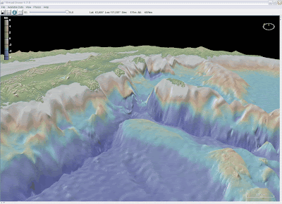
As important and revolutionary as the Keyhole MarkUp Language (KML) has been to the widespread use of virtual globes for visualization of geospatial data, there is a lack of adequate structure for the content of the tag that is most commonly used to deliver associated data objects. Our Virtual Ocean globe (www.virtualocean.org) offers a prototype solution using a spreadsheet or an ascii stream with XML tags from a Web Feature Service to supply the content. This solution has the necessary consistent and self-described format to allow interaction with the symbols, polygons and images so that the virtual globe becomes a tool for interactive data manipulation and analysis. Although the and tags now permit the efficient viewing of large images as individual tiles, the required code within a single kml file is rather intricate and lengthy and must be customized for each large image. This complexity can be reduced with a short and simple kml file linked to a cgi-script in a network server. The server script computes and returns the necessary image tiles to the virtual globe as areas come into view with changing perspectives and resolutions. This "pseudo" Web Mapping Service demands little computational overhead from either the virtual globe or the server. A large number of placemarks or polygons often reduces performance in a virtual globe if the graphics are to be constantly recomputed and redrawn as individual line segments and icons. We offer a solution in Virtual Ocean where the graphics are drawn to transparent images and just the image tiles are displayed. Thus the graphics engine in the client computer is only called upon to wrap the resulting images into their respective locations. Consequently thousands of polygons and tens of thousands of placemarks can be displayed and manipulated without degradation of performance. Virtual Ocean uses Java classes adapted from our GeoMapApp application and NASA World Wind.
Read more:
Read more:
Ingen kommentarer:
Send en kommentar