tirsdag den 30. december 2008

See Im Green


Så amerikansk ...
/Sik


Save the world - make this a better place ...
/Sik


Quote

Put a map marker () over your house to let your neighbors (and the world) know that you have gone green.  Click on the map markers to read the profiles of other homes, businesses and organizations that care about the environment. Get started by clicking on this link:Add me.


This site is designed for both the lifelong eco-enthusiast and the consumer who is just starting to learn about our environmental impact. We hope you will both contribute and learn from others in our discussion boards by clicking on this link: Learn/Discuss.  As a new website, we would love to get your feedback on how to improve things by clicking on this link: Feedback.  To learn more about the site, be sure to visit our Frequently Asked Questions section by clicking this link: FAQ.  [...]


Read more: http://www.seeimgreen.com/

Web 2.0/RIA Developers – Business Mapping Products


Var det noget? Skulle man gøre ESRI mere farverig og mere brugervenlig? Rart at se at ESRI også satser på FLEX, AIR og AJAX og ikke kun tænker på serverudvikling sammen med Microsoft ...
/Sik


A position for you? Why not make ESRI more lively and user friendly? Nice move by ESRI by making FLEX, AIR and AJAX taking on the stage and not always focus on server development together with Microsoft ...
/Sik


Quote

Position Detail

Organization: ESRI
Title: Web 2.0/RIA Developers – Business Mapping Products
Location: Redlands, CA
Application Deadline: 
Posted: 2008-12-29

Position Description:

Create a suite of business mapping applications that changes the way people make decisions about where to locate a business and market their products. Our Business Solutions team is searching for exceptional software architects and Web developers to create applications in Adobe Flex and AIR that set the benchmark for usability and desirability. In this role you will work with a small, highly accomplished team of product managers, engineers, and top-notch user experience design specialists that adhere to the principles of agile software development.

As a GIS professional at ESRI your contributions have a real impact on the next generation of GIS technology. Our product development staff works in a creative and challenging team setting where their ideas are encouraged and welcomed. This dynamic work environment allows employees to collaborate and guide a product along, giving them the opportunity to see an idea become a successful GIS software solution. We are looking for GIS professionals who have the skills and the mindset to thrive in a constantly changing, cutting-edge environment. 

Responsibilities:
Design, develop, and implement enterprise applications for the Web.
Develop in various Web environments such as Flex, JavaScript, and other languages.
Work closely with other developers to design and develop software components for the management, manipulation, and display of a wide variety of GIS data.
Release product on schedule.

Requirements:
Bachelors or masters in computer science, engineering, mathematics, GIS, or a related field, depending upon position level.
A minimum of two years of software development experience including designing and developing large Web software systems and experience developing in Flash/Flex or AJAX.
Strong analytical skills and ability to find sound solutions for software requirements.
Familiarity with relational databases, SQL, and the latest trends in Web development.
Effective time management, organization, and verbal and written communication skills.
Ability to work with a team to meet objectives.

Recommended Qualifications:
Knowledge of and experience developing on-line consumer based applications.
Knowledge of and experience developing applications for business, retail, and customer analytics.

Since 1969, ESRI has been giving customers around the world the power to think and plan geographically. We develop and support innovative tools for visualizing, analyzing, and managing geographic data on the desktop, on a server, across the enterprise, in a mobile environment, and on the Web. With annual revenues of $660 million and our software used in more than 300,000 organizations worldwide, ESRI is the market leader in GIS. 

ESRI employs 2,700 people in the U.S., 1,900 of whom are based at our Redlands headquarters, a community ideally located in Southern California. We offer exceptional benefits, competitive salaries, 401(k) and profit sharing programs, scholarships, tuition assistance, a Cafe complete with Starbucks coffee bar, an onsite fitness center, and much more. 

Learn more about a career in Product Development at ESRI and apply online at www.esri.com/giscareers.


Read more: http://www.gjc.org/gjc-cgi/showjob.pl?id=1230579962

Virtual Earth Data Release – December, 2008


Det er næsten den samlede mængde af data som skulle konverteres da kommunalreformen skulle gennemføres i 2006 ...
/Sik


48TB ... 
/Sik


Quote

We’ve been doing some housecleaning the last 2 months with some of our road network data. As a result, a small blog post to let you know of a HUGE refresh / release (48TB worth) of all tile sets where vector information is included – Road, Hybrid Aerial, and Hybrid Bird’s Eye. [..]

Read more: http://blogs.msdn.com/virtualearth/archive/2008/12/29/virtual-earth-data-release-december-2008.aspx

Google 'set to launch Street View service in the UK in spring'


Street view komer tættere og tættere på ...
/Sik


Street view is coming nearer and nearer (to Denmark) ...
/Sik


Quote

By DAILY MAIL REPORTER

A new internet service that allows people to virtually wander around cities will be launched by Google in the UK in spring.

Google Street View uses millions of 3D video images that are stitched together to create a virtual replica of city streets.

But critics say the site is a 'burglar's charter' that makes it easy for criminals to check out potential victims. 

The service was launched in major American cities last year and is now available in France, Italy, Australia, New Zealand, Japan and South America. [...]

google

Enlarge

Read more: http://www.dailymail.co.uk/sciencetech/article-1102502/Google-set-launch-Street-View-service-UK-spring.html?ITO=1490

The Advance of GEOINT


Hørte Oberst John Fennell, NATO Allied Joint Force Command ved Kortdage 2008 hvor han talte om Maps in Modern Warfare ... Meget spændende og inspirerende - tænk sig GIS som bliver brugt til noget ...
/Sik


Heard Oberst John Fennell, NATO Allied Joint Force Command at the Kortdage 2008 conference talking about Maps in Modern Warfare ... very exciting and inspiring - image GIS actually being used ...
/Sik


Quote

By Lloyd Rowland , National Geospatial-Intelligence Agency 
December 29, 2008 
In 2000, we began to experiment with fusing imagery, imagery intelligence and geospatial information. This conceptual experiment gained significant momentum after Sept. 11, 2001. We were among the first to answer the call for unified intelligence operations that were at the forefront of the nation's consciousness. Today we are expanding the GEOINT footprint, pushing forward in fusing GEOINT with other intelligence disciplines and exploiting the digital environment. Our goal is to make sure policymakers, warfighters, and other end users have the GEOINT advantage. Whether our partners need a hardcopy map, a physical model, 3-D visualization or fused intelligence, NGA is there to give them the critical edge. [...]

Capture.NET: A Swiss Army Knife For Your PC


Prøvede at hente den og nu sidder den allerede fast på min desktop. Umiddelbart ser den meget anvendelig ud og vi får se hvor længe den får lov at blive siddende ;-)
/Sik


Downloaded it and now it sits comfortably on my desktop. At first glance it does look quite handy and time will show how long it gets to stay ... ;-)
/Sik


Quote

I am talking about capture.NET. The tool is aptly called the Swiss army knife of PC tools because it just does so many things. I must confess that after looking at the site and its presentation I was a little wary of malware. However I submitted the file to VirusTotal and the results were 0 positive on 38 engines, so I went ahead and double-clicked to launch.

Cloud platforms of the future: Hadoop and Eucalyptus


Open Source cloud computing ... nu mangler vi bare 'open source' hosting ...
/Sik


Open Source cloud computing ... now we only need 'open source' hosting ... 
/Sik


Quote

Posted by Dave Rosenberg

Without a doubt, the cloud and all its forms and meanings were big news in 2008. Besides the huge growth of Amazon EC2 and Google App Engine, we saw Salesforce launch Force.com, a true platform-as-a-service.

My picks for the most interesting software of 2008 are Hadoop and Eucalyptus.

Hadoop is an Apache project, the "open source implementation of MapReduce, a powerful tool designed for the detailed analysis and transformation of very large data sets," which basically means you can process a ton of data on commodity hardware.

Hadoop is going commercial through Cloudera and while details are not publicly available, let's just say there are some very important and interesting foundations being laid for the way that people deal with computing and processing power.

Eucalyptus is an "open-source software infrastructure for implementing 'cloud computing' on clusters. The current interface to Eucalyptus is compatible with Amazon's EC2 interface, but the infrastructure is designed to support multiple client-side interfaces. Eucalyptus is implemented using commonly available Linux tools and basic Web-service technologies making it easy to install and maintain." [...]


Read more: http://news.cnet.com/8301-13846_3-10128773-62.html

J2EE for objects with geographical attributes


Et speciale om GIS og hvor ArcGIS er anvendt ... spændende, men lidt tyndt ...
/Sik


A master thesis on GIS using ArcGIS ... interessting through a bit light ...
/Sik


Quote

Objects with geographical attributes are often complex in their structure and difficult to handle in all environments. The purpose of this Master thesis is to investigate how to update objects with geographical attributes from Web-based clients in a Java 2 Platform, Enterprise Edition application server, using the new framework from ESRI called ArcGIS 9.0. Since the new product ArcGIS Server has capabilities of making GIS data available through a network and also can be used for developing distributed applications, this has been the focus of the investigation. The product has been installed and two sample applications written in Java have been implemented to test its abilities. [...]

Read more: http://www.projectsparadise.com/j2ee-objects-geographical-attributes/

Microsoft's Cloud Tax


Intet er gratis ... Når software, netværk og hardware smelter sammen bliver prisen derefter ...
/Sik


nothing comes for free ... When software, net work and hardware are bundled together the price will be ... ??
/Sik


Tax free

Quote

December 24, 2008

In the cloud, existing infrastructure is irrelevant. A well-built cloud application uses the network as its integration point and can exchange data with any other application, whatever the underlying technology.

That leaves the "I have an army of (insert your technology of choice) programmers" argument. In general, it's a powerful argument. If you are going with .NET + SQL Server in the cloud, this one reason ends up having a heavy Microsoft tax associated with it.

In short, you pay a significant tax to Microsoft for the privilege of building your web applications in .NET + SQL Server in the cloud without getting any functional benefits for doing so.

Microsoft Other Tax
App Server$4,380/year $3,504/year$876/year
DB Server$9,636/year$3,504/year   $6,132/year
Baseline System  $28,908/year $14,892/year
$14,016/year

New Features: Team Maps and Quiz Maps


FYI
/Sik


FYI
/Sik


Map Channels

Quote

Two new features have been released at Map Channels this month:

[1] Team Maps (www.mapchannels.com/TeamMaps.aspx) : Use Team maps to embed a map which can be edited by visitors to your web site or blog. Extensive options are available to customize the map data and presentation.

[2] Quiz Maps (www.mapchannels.com/QuizMaps.aspx) : Test your geographical and anagram solving skills with Quiz Maps. Separate quizzes are available for World capitals and US state capitals with Panoramio images used as quiz clues. Also Map Search, Wikipedia and Panoramio layers are available when the quiz is not running.

Please send any comments and suggestions to us at mapchannels@gmail.com. Thanks to all the users who have helped development with feedback and donations over the past year. More new projects are due for release early in the new year.

Read more: http://www.mapchannels.com/

fredag den 26. december 2008

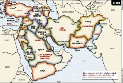
The Middle East Redrawn


Religion ... udover penge (som for nogen er en religion) er der få andre ting som har påvirket menneskeligheden i så stor grad - og sammen med menneskene har det også påvirket de grænsedragninger som vi kender idag. Specielt i mellemøsten går det hårdt for sig og det er tvivlsomt om det nogensinde får en ende ...
/Sik


Religion ... apart from money (which for some is a religion) very few things have impacted on human life at such a large degree - and along with humans, borders have shifted too. Especially in the middle east is has been hot for centuries ... is is doubtful wether it will ever end ... 
/Sik


Quote

Redrawn Middle East Map

An article by Ralph Peters in the June 2006 issue of the Armed Forces Journalimagines a redrawn map of the Middle East, where borders are shifted and new states are created to address local — and, thanks to the attention given to the Israel-Palestine situation, less well-known — injustices: ethnic groups separated by international borders are united, stateless minorities are given homelands (e.g. Kurdistan). No more than a thought experiment, but one bound to generate controversy. [...]


Read more: http://www.mcwetboy.net/maproom/2006/09/the_middle_east.php

torsdag den 25. december 2008

Mapping Celestial Terrains, in All Their 3-D Glory


Hvad er det som vi mennesker får ud af at en videnskabsmand kan kortlægge en fjern måne i 3D? Viden om fjerne himmellegemer som på en eller anden sær vis også gør os klogere på vores egen lille klode. Nogen gange ligger svaret et helt andet sted end forventet - nogen gange er det vejen til et svar som er svaret på et andet langt nærere problem.
/Sik


What do humanity get from the knowledge of far away celestian objects in 3D? Some how this knowledge makes us more knowing about our own world. Sometimes the answer to one problem is to be found in unexpected places - sometimes it is the road to one solution that might be the answer to another unsolved problem.
/Sik


Quote

Published: December 22, 2008

ALTADENA, Calif. — When space engineers made a map of a planet or a distant moon back in the old days, they made an 8-by-10 picture of part of the surface, identified a couple of landmarks — a crater and an outcrop, say — and measured the distance between them with a straightedge and a crayon. [...]


Read more: http://www.nytimes.com/2008/12/23/science/23prof.html?_r=1&ref=technology

Cloud Computing Events for 2009


Fra jeg først hørte om Cloud Computing tilbage i juli (http://gisdk.blogspot.com/2008/07/cloud-computing.html) og til nu er der sket rigtig meget ... og nu taler jeg kun ud fra den mængde af informationer som er dukket op på nettet siden da. Antallet af indlæg er steget eksplosivt og det er kun begyndelsen vi har set. I august faldt jeg for første gang over begrebet geo cloud (http://gisdk.blogspot.com/2008/08/what-is-geocloud.html) men der har været noget stille siden da - jeg håber ikke at GIS verdenen misser denne chance for at komme ud til alle - jeg frygter at det er GIS leverandørernes software licenser som hiver den varme luft ud af GIS ballonerne ...
/Sik


Since I first mentioned Clou Computing back in July (http://gisdk.blogspot.com/2008/07/cloud-computing.html) and until now quite a lot has happened ... and I only speak on basis of what I have observed on the net and on the amount of information that has emerged. The number of posts has risen enormously and yet we have only seen the beginning of it. Back in August I first stumbled over the what was called the Geo Cloud (http://gisdk.blogspot.com/2008/08/what-is-geocloud.html) but since there has not been much talk about it - I fear that GIS is missing a great uppertunity here to go really main stream and hit everybodys desktop - and I am afraid the main reason is the license policies defined by the leading GIS vendors ...
/Sik


Quote

Posted by: Dmitry Sotnikov on: December 24, 2008

With Cloud Computing taking all the media attention, rapidly growing and generating so much hype no wonder that various industry events are starting to sprawl. Here’s my attempt to put together the schedule of the cloud computing conferences announced for 2009: [...]


Read more: http://cloudenterprise.info/2008/12/24/cloud-computing-events-for-2009/

The State of the Map 2009 is Coming to Amsterdam


Open source har vist sit værd og i de seneste år har open source indenfor for kortdata også begyndt at vise sit værd. Data har det bedst hvis det er fælles data - ingen kommerciel organisation uanset størrelse kan vedligeholde den mængde at kortdata som der findes - det kan kun lade sig gøre hvis man løfter i fælles flok ...
/Sik


Open source has shown us that there is an alternative to commercial companies and over the last few years the same tendency has been evident for map data. No matter how big an organisation you have it's only gonna work if everybody contribute ...
/Sik


Quote

It was the first country to be completed in OpenStreetMap, its the home of TomTom, TeleAtlas, AND, a thriving OSM community and now its hosting the State of the Map.  This July, Amsterdam will host the greatest gathering of OSMers the world has ever seen.  The State of the Map 2009 will build upon the success of the last two events by adding a third day to the event. [...]

Earthstruck


At kunne se hele jorden på én gang må være helt fantastisk ... Noget som kun meget få har oplevet live ...
/Sik


Being able to see the whole earth at once must be a great experience ... Something only very few have been able to do live ...
/Sik


Quote

Forty years ago today, the crew of Apollo 8 gave the planet what this page called “an ennobling Christmas present.” The astronauts — Frank Borman, James A. Lovell Jr. and William A. Anders — orbited the Moon, beaming pictures home in two live broadcasts, one in the morning and one later that evening. They read the first verses of Genesis, then signed off. “Goodbye. Goodnight,” Colonel Borman said. “Merry Christmas. God bless all of you, all of you on the good Earth.” [...]

The Natures of Maps

Book


Cartographers have known for decades that maps are far from objective representations of the world; rather, every map reflects the agendas and intentions of its creators. Yet that understanding has had almost no effect on the way maps are viewed and used by the general public. In The Natures of Maps, cartographers Denis Wood and John Fels present a compelling exploration of a wide range of maps to answer the question of, as they put it, why maps have “gotten away with it.”
            To answer that question, the authors turn to a category of maps with a particularly strong reputation for objectivity: maps of nature. From depictions of species habitats and bird migrations to portrayals of the wilds of the Grand Canyon and the reaches of the Milky Way, such maps are usually presumed—even by users who should know better—to be strictly scientific. Yet by drawing our attention to every aspect of these maps’ self-presentation, from place names to titles and legends, the authors reveal the way that each piece of information collaborates in a disguised effort to mount an argument about reality. Without our realizing it, those arguments can then come to define our very relationship to the natural world—determining whether we see ourselves as humble hikers or rampaging despoilers, participants or observers, consumers or stewards.
            Richly illustrated, and crafted in vivid and witty prose, 
The Natures of Maps will enlighten and entertain map aficionados, scholars, and armchair navigators alike. You’ll never be able to look at Google Maps quite the same way again.


tirsdag den 23. december 2008

New Improved Ancient Rome 3D


Jeg havde problemer med at se byen for bare polygoner ... det kan være jeg skulle prøve igen ...
/Sik


I had problems seeing Rome ... perhaps I should try again now ...
/Sik


Quote

When Google introduced the new Ancient Rome 3D layer last month there was a problem. The problem was the building models were derived from very complex data and the resulting 3D models in Google Earth were still too complicated for most computers to handle. I did some testing and it was clear in some cases a single building in Ancient Rome had tens to hundreds of thousands of polygons (a typical 3D building model in Google Earth may only have a few dozen or a couple of hundred polygons). It was little wonder there were many complaints that the new layer was too slow for most people to really use.

Well this past week, Google pushed out new improved Ancient Rome 3D models where the models have been simplified a great deal. I haven't seen an announcement yet, but I found out last week the models were much better. It still can take a few minutes to load the terrain and buildings (depending on your Internet connection and computer). But, I'm able to run the new layer on my Mac Book Pro laptop and fly around and look at the buildings much more fluidly than before. Building polygon counts are much better now. [...]


Read more: http://www.gearthblog.com/blog/archives/2008/12/new_improved_ancient_rome_3d.html

Dataset of the Day: Another Look at Flickr Data


Der er bare et eller andet som gør de kort man kan lave med Mapper fra geocommon lidt mere lækre at se på end så mange andre kort. Desuden er mængden af data efterhånden overvældende så det er bare med komme igang med at lave kort ... 
/Sik


There is just something about the maps you can create using Mapper from geocommons. They are just that bit more nice to look at. Add to this the vast amount of data available - just you get staring creating maps ...
/Sik


Quote

December 23rd, 2008by Bill Greer

Flickr recently published the areal shapes of place names based on geotagged photos.Tom Taylor quickly developed a visualization for any particular place name.
The shapes are irresistible. We added a few locations into Geocommons. The data includes counts of the number of photos taken for any particular place name. For a better idea of what this looks like, take a look at San Francisco flickr data on OpenStreetMap:

[...]

Finally, I wondered whether it was just geeks like myself who geo-tagged their photos, so I loaded the crunchbase and flickr data into a global map:


Read more: http://blog.fortiusone.com/2008/12/23/dataset-of-the-day-another-look-at-flickr-data/