Vejret er noget vi alle kan forholde os til, kun få kan forstå og ingen kan forudsige ...
/Sik

I can feel it coming in the air tonight ...
/Sik
Quote
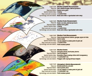
 The Atmospheric data model initiative is establishing a working dialog between ESRI and the atmospheric sciences community regarding data representation issues. This helps serve to address the needs of the atmospheric community for ESRI software development. The management of temporal data and raster data support are two areas of focus with this initiative.
 Collaboration with NCAR/UCAR, NASA JPL, and Raytheon has helped to identify the need for direct read of CF compliant netCDF data. The functionality is in development for the direct read and write of NetCDF as feature, raster, and tabular data. This will also be useful to perform analysis using standard feature, raster, and table Geoprocessing model builder tools for netCDF data.
The initial task in developing an Atmospheric Data Model is to identify the purpose and scope of the final design. A questionnaire will be used as the basis for a Conceptual Framework Document to shape the design of the Atmospheric data model, for the query, analysis, storage, and display of Atmospheric data in a GIS format. [...]
Read more: http://gisandscience.com/2009/06/30/atmospheric-data-model-for-arcgis/
Read more: http://gisandscience.com/2009/06/30/atmospheric-data-model-for-arcgis/
Ingen kommentarer:
Send en kommentar