Se stormen komme! Følg udviklingen real time på nettet.
/Sik

See the storm comming! Follow the events real time on the net.
/Sik
Quote

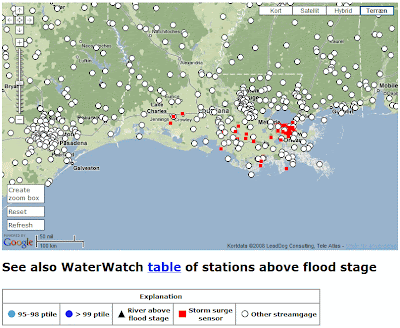
The “Hurricane Gustav Hydrologic Impacts Map” shows the location of streamgages where the water level is currently at or above flood stage (depicted as a black triangle) or at a historical high discharge (depicted as blue circles); other USGS streamgages are depicted as open circles. The map also shows the location of storm surge sensors (red squares) which monitor water levels in rivers and canals. The high flow conditions are expressed as percentiles that compare the current (i.e., within the past several hours) instantaneous flow value to historical (period of record) daily mean flow values for all days of the year at that site. The real-time data used to produce this map are provisional and have not been reviewed or edited. They may be subject to significant change.
Please note that flood conditions may be more extensive than shown on the map because the National Weather Service (NWS) has not identified a flood stage (for flood forecasting purposes) at all USGS streamgages. Also, the NWS has determined flood stages for some non-USGS streamgages that are not shown on the map. The most complete depiction of streamgages at or above flood stage is on the NWS River Observations Map.
[...]
Read more: http://water.usgs.gov/waterwatch/gustav/


